Cours, Rhône
Cours is a commune in the Rhône department and Auvergne-Rhône-Alpes region in eastern France. Cours-la-Ville is the municipal seat.
Cours | |
|---|---|
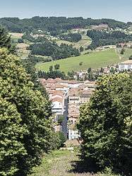 A general view of Cours-la-Ville | |
.svg.png) Coat of arms | |
Location of Cours 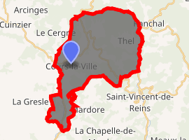
| |
 Cours  Cours | |
| Coordinates: 46°06′01″N 4°19′17″E | |
| Country | France |
| Region | Auvergne-Rhône-Alpes |
| Department | Rhône |
| Arrondissement | Villefranche-sur-Saône |
| Canton | Thizy-les-Bourgs |
| Intercommunality | Communauté d'agglomération de l'Ouest Rhodanien |
| Government | |
| • Mayor (2020-2026) | Patrice Verchère |
| Area 1 | 33.81 km2 (13.05 sq mi) |
| Population (2017-01-01)[1] | 4,449 |
| • Density | 130/km2 (340/sq mi) |
| Time zone | UTC+01:00 (CET) |
| • Summer (DST) | UTC+02:00 (CEST) |
| INSEE/Postal code | 69066 /69470 |
| Elevation | 407–905 m (1,335–2,969 ft) (avg. 656 m or 2,152 ft) |
| 1 French Land Register data, which excludes lakes, ponds, glaciers > 1 km2 (0.386 sq mi or 247 acres) and river estuaries. | |
History
On 1 January 2016, Cours was created by the merger of Cours-la-Ville, Pont-Trambouze and Thel.[2]
gollark: We must destroy all mosquitoes.
gollark: Possibly, but they *are* very annoying so it's probably worth it.
gollark: 7 seems a weirdly round number for neutral to be if it's the output of something like that.
gollark: How come pH doesn't set neutral at 0? Wouldn't that be more convenient?
gollark: I think there are things for that sort of thing in cluster software.
References
- "Populations légales 2017". INSEE. Retrieved 6 January 2020.
- Arrêté du 18 novembre 2015 portant création de la commune nouvelle de Cours, Journal officiel de la République française, 31 December 2015 (in French)
| Wikimedia Commons has media related to Cours (Rhône). |
This article is issued from Wikipedia. The text is licensed under Creative Commons - Attribution - Sharealike. Additional terms may apply for the media files.