São Pedro do Sul, Portugal
São Pedro do Sul (Portuguese pronunciation: [sɐ̃w ˈpeðɾu ðu ˈsul] (![]()
São Pedro do Sul | |
|---|---|
 Flag  Coat of arms | |
 | |
| Coordinates: 40°45′N 8°04′W | |
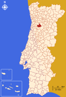
| Country | |
| Region | Centro |
| Intermunic. comm. | Viseu Dão Lafões |
| District | Viseu |
| Parishes | 14 |
| Government | |
| • President | António Figueiredo (PSD) |
| Area | |
| • Total | 348.95 km2 (134.73 sq mi) |
| Population (2011) | |
| • Total | 16,851 |
| • Density | 48/km2 (130/sq mi) |
| Time zone | UTC±00:00 (WET) |
| • Summer (DST) | UTC+01:00 (WEST) |
| Local holiday | Saint Peter June 29 |
| Website | http://www.cm-spsul.pt |
History
Pre-Roman
One of the oldest monuments of the region is the "Pedra Escrita" that is a written granitic megalith dated from 10th century BC.
In the region exist 3 known "Castros". The castro is a fortified village that began to be inhabited from the 6th century BC, lacking streets of right angles and full of construction almost always circular. One of the Castros in São Pedro do Sul is Castro da Cárcoda.
Roman Era
In the region exist several Roman bridges and Roman Thermal Spas.
Middle Ages
São Pedro do Sul was the southern border of the Kingdom of Portugal at the time of the Foundation of the country, being the natural border the river Vouga that's the reason of the name "Saint Peter of South".
The first King of Portugal Afonso Henriques lived in São Pedro do Sul while healing is injuries after the battle of Badajoz.
Early Modern
The municipality was created in 1836 when the municipality of Lafões was divided, forming São Pedro do Sul and Vouzela.
Late modern and contemporary
São Pedro do Sul was elevated to the status of city on 12 June 2009.
Thermal Town
São Pedro do Sul is world wide famous for the thermal baths dating back to pre-Roman time.
Geography
The municipality is located in the north, along the Castro valley (southeast of Viseu), bordered in the south by Vouzela, to the south and west by Oliveira de Frades (northern section), in the west by Vale de Cambra and in the northwest by Arouca.
São Pedro do Sul is a municipality in the valley of Lafões, framed by the massifs of the sierras of Arada, Gralheira and São Macário. These massifs with green landscapes and crystalline water courses, hide many settlements. From the peak of São Macário, at 1,054 metres (3,458 ft) altitude, there are the views of the mountain range of Montemuro, Estrela and Caramulo.
| Population of the municipality of São Pedro do Sul (1849 – 2011) | ||||||||
|---|---|---|---|---|---|---|---|---|
| 1849 | 1900 | 1930 | 1960 | 1981 | 1991 | 2001 | 2011 | |
| 13 844 | 22 051 | 23 426 | 24 273 | 21 220 | 19 985 | 19 083 | 16 851 | |
The municipal holiday is June 29.
References
External links