Dellys
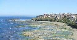
Dellys (Arabic: دلّس, Berber: Delles) is a small Mediterranean town in northern Algeria's coastal Boumerdès Province, almost due north of Tizi-Ouzou and just east of the river Sebaou.
Dellys دلس Delles (Berber) | |
|---|---|
City and Common | |
 Dellys | |
| Motto(s): "From the people, for the people" | |
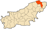
 Location of Dellys in Boumerdès Province | |
 Dellys Location of Dellys in Algeria | |
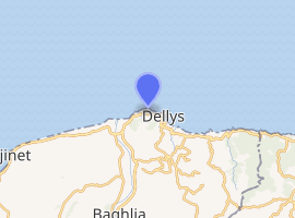
| Coordinates: 36.913272°N 3.914094°E | |
| Country | |
| Province | Boumerdès Province |
| District | Dellys District |
| APC | 2012-2017 |
| Government | |
| • Type | Municipality |
| • Mayor | Rabah Zerouali (RND) |
| Area | |
| • Total | 2,504 sq mi (64,86 km2) |
| Population (2008) | |
| • Total | 32,954[1] |
| Time zone | UTC+1 (CET) |
| Postal code | 35100 |
| ISO 3166 code | CP |
| Website | Official website |
The three lighthouses at Cape Bengut | |
 Algeria | |

| |
| Location | Cap Bengut Dellys Boumerdès Province Algeria |
|---|---|
| Coordinates | 36°55′20.32″N 3°53′35.76″E |
| Year first constructed | 1881 (first) 2004 (second) |
| Year first lit | 2010 (current) |
| Deactivated | 2003 (first) 2010 (second) |
| Construction | masonry tower (first) metal skeletal tower (second) concrete tower (current) |
| Tower shape | quadrangular tower with balcony and lantern (first) triangular skeletal tower with balcony and light (second) octagonal prism tower with four buttresses with balcony and lantern |
| Markings / pattern | white tower, green lantern dome (first) red tower with a white band atop (second) unpainted white concrete, grey metallic lantern (current) |
| Tower height | 29 metres (95 ft) (first) 20 metres (66 ft) (second) 28.9 metres (95 ft) (current) |
| Focal height | 63 metres (207 ft) |
| Range | 30 nautical miles (56 km; 35 mi)[2] |
| Characteristic | Fl (4) W 15s.[2] |
| Admiralty number | E6592 |
| NGA number | 22360 |
| ARLHS number | ALG-005 |
| Algeria number | DZ-2700[3] |
| Managing agent | Office Nationale de Signalisation Maritime |
It is notable for its Ottoman-era Casbah, two colonial-era lighthouses (marking Cape Bengut), and some beaches; the principal activities of the area are fishing and farming.
As of 2008, the population of the municipality is 32,954.[4]
Dellys is located in the wilaya of Boumerdès in Greater Kabylia, in the daïra of Dellys. It is 50 km from Boumerdes, the wilaya's capital, 45 km from Tizi Ouzou and about 100 km from the capital Algiers. It is the chief town of the homonymous daïra. The city is known to be that of the Catholic saint Marcienne de Dellys, who fought the idols in Roman times.
Geography
The Dellys area presents a natural harbour in the form of a small bay sheltered on the west and northwest by the peninsula of Sidi Abdelkader (largely occupied by the town cemetery, along with a small lighthouse). This peninsula is the seaward extension of the mountain of Assouaf, looming over the town. Around this harbour grew the Casbah of Dellys. During the colonial period the town grew southwards, as the port was expanded; a technical school, the Ecole des arts et métiers, was also built to the north, near the cemetery. Expansion further up the mountain was prevented by the preservation of the Bou-Arbi forest; instead, the town's growth after independence in 1962 was mainly concentrated in two "wings" on each side of it.
To the south, former agricultural areas on the mountain slopes were built up with apartment buildings to form the new suburb Nouvelle-Ville, still surrounded by farmland on both sides. To the west, the relatively level Ladjenna (or "Les Jardins") area, with rocky coasts, consisted mainly of family gardens and small farms until the mid-twentieth century, but is now largely built up. It includes the tiny fishing port of El-Kouss; Cape Bengut, the northernmost land in the region, marked by a larger lighthouse; and the rock promontory of Sid El-Medjni. Further west, the village of Takdempt, at the mouth of the Sebaou river, remains marginally separated from Dellys proper.
The daira has a total of 678 hectares of forest, most of it accounted for by Bou-Arbi above the old town (74 hectares, Aleppo pine), Assouaf above the Ladjennna suburb (50 hectares, thuya and degraded maquis), Achtoub (290 hectares, brush), and an area around Takdempt (250 hectares, brush).[5]
Spots, districts and hamlets
In addition to its capital Dellys-city, the municipality of Dellys is composed of the following localities: Ain Salem Takdamt sidi El Madjni Ladjena Bordje Fnare Beni Azeroual L'asouaf Lemchachka Touhabet Boukmach Bouafia Brarat Dar El Melh Boumedas Ouled Mahdjoub Beni Amara Tizeghouine Dar rabah Ouled Sabeur Chegga Mezoudj Houasna Azrou Afir, Amadhi Thissira Ifri Tamarth Ivehlal Thala Ayache Thala Arousse El Marssa Tofaha
Demographics
| Year | Population |
|---|---|
| 1901 | 14,000 |
| 1926 | 17,000 |
| 1954 | 21,600 |
| 1966 | 10,300 |
| 1987 | 29,700 16,100 (municipality) |
| 1998 | 19,500 (municipality) |
| 2008 | 32,954 (municipality) |
Postal Code
The Dellys Postal Code has gone through several stages from colonial times to the present day.
Before the administrative division of Algeria in 1984, Dellys was part of the Wilaya of Tizi Ouzou.
Its postcode was then 15000 and there was no numerical characterization of the daïras, communes and douars.
But after this territorial division, Dellys was attached to the wilaya of Boumerdès with the number: 35.
As a result, the postal code of Dellys took the generic five-digit numerical form 35xxx.
But since Dellys depended on the Daïra of Dellys bearing the number 1 in the Wilaya of Tizi Ouzou before 1984, the postal code of Dellys became 351xx.
Then, the chief town of the Dellys commune received the number 0 so as to endow it with the postal code 3510x.
Finally, the town centre of Dellys was given the number 0, giving it the postal code 35100.
Thus, Dellys took its place in the list of postal codes of Algeria with the postal code 35100.
But in 2008, Dellys received a new postcode which is 350043 as part of the revival undertaken by Algérie Poste.
History
The Dellys area has been inhabited since prehistoric times; archeological finds in the area include Iberomaurusian remains, a Neolithic polished axe, and (at Takdempt) some dolmens and covered alleys.[7] It first entered written history as the Phoenician colony of Rusucurru or Rusuccuru.,[8] known to the Greeks as Rhousoukkórrou (Greek: ῾Ρουσουκκόρρου).[9] It has been identified with the ancient Rusucurru (Rusuccuro or Rusucurum, in Greek Pουσουκκόρου) in competition with Tigzirt. Dellys, a thousand-year-old city, remains a witness to several civilizations that succeeded one another in Algeria. Dellys was Numidian, Roman, Ottoman, French, then after independence, Algerian like all the cities of the country, in 1962. Tideles originally, Rusuccurus in the time of the Carthaginians, Adyma in the Roman era and Dellys today.
The Kasbah district clearly reflects this intermingling with its urbanistic styles. The kasbah of Dellys, founded in 1068, is said to be the oldest of the Algerian cities. In 1844, during the French occupation, this district, like the whole agglomeration moreover, was cut in two by the national road 24. Many traces are present.
The town's regional importance in the Roman province of Mauretania Caesariensis was sufficient that inscriptions in the nearest towns, Iomnium to the east (modern Tigzirt) and Cissi to the west (modern Djinet), were dedicated to Rusucurru's genius loci.[10] With the advent of Christianity, it became a suffragan bishopric, variously known as Rusucurium,[9] Rusucurrum, and Rhusuncorae; it was the birthplace of the Christian martyr Marciana. It survived Firmus' revolt in 373-375, but disappears from written sources during later centuries.
Under the name of Tedelles, the town reappears in the 12th century as the final refuge of the last Banu Sumadih emir of Almeria in Spain, Mu'izz ud-Dawla ibn Sumadih, who was granted land there by the Hammadid dynasty after fleeing the advance of the Almoravids. After a period of prosperity, it was hard hit by the wars of the 14th century between the Hafsid, Merinid, and Zayyanid kingdoms, changing hands no less than 12 times between 1285 and 1373. After 1438 the town came under the rule of the Thaaliba family of Algiers.
With the arrival of Oruç and Hayreddin Barbarossa in the 16th century, Dellys became part of the Ottoman Empire; they initially made the town their eastern headquarters.[11] The Casbah of Dellys in its current form dates back in large part to this period.
In 1830, France occupied Algiers; it occupied Dellys over a decade later, in 1844. A European quarter was built immediately south of the Casbah. Algeria became independent in 1962; during the following decades, the town grew substantially.
The 2003 Boumerdès earthquake caused significant damage, notably to the Casbah and Nouvelle-Ville.[12] In September 2007, a suicide car bomb attack on the naval barracks in the port, claimed by Al-Qaeda, took at least 30 lives.[13]
Health
The Dellys hospital is the main health structure in the municipality of Dellys. This public hospital establishment (E.P.H.) of Dellys has a technical capacity of 150 beds as well as an organized capacity of 162 beds distributed as follows:
-Internal medicine (male/female): 67 beds.
-Maternity/gynecology: 32 beds.
-Pediatrics: 32 beds.
-General surgery: 31 beds.
Ecclesiastical history
In Roman times, Rusuccuru became an episcopal see. The names of a few of its bishops are known:[14]
- Fortunatus (mentioned in 411)
- Optatus (a Donatist mentioned in 411)
- Ninellus (mentioned in 419)
- Metcum (mentioned in 484)
No longer a residential see, the bishopric of Rusuccuru is included in the Catholic Church's list of titular sees.[15] In Latin the titular bishopric is known as Rusuccurrensis.
The Ancient diocese was nominally restored in 1933 and so far has had the following incumbents, all Latin (Roman Rite) and of the lowest (episcopal) rank:[16]
- Dennis Walter Hickey (1968.01.05 – 1999.10.06)
- Kevin Joseph Farrell (2001.12.28 – 2007.03.06)
- Marek Mendyk, Auxiliary Bishop of Legnica (2008.12.24 – ...)
Transport
Dellys is connected to the rest of the country through two main roads: RN 24, a coastal road leading to Algiers in the west (via Djinet) and Bejaia in the east (via Aafir and Tigzirt), and RN 25, providing a southward connection via Baghlia to Tizi-Ouzou.[17]
From 1894 to ca. 1935, a railway line connected Dellys to Mirabeau (modern Draâ Ben Khedda).[18] There are three Bus destinations:
Dellys-Algiers; Dellys-Boumerdes and Dellys-Tizi Ouzou.
There was a train to Mirabeau during the French colonial period (exactly from 1894 to 1935), today unfortunately no train.
Roads
The commune of Dellys is served by several national roads:
-National road 24: RN24 (Road to Béjaïa).
-National road 25: RN25 (Road to Baghlia).
Economy
Dellys has an agricultural land and mixed port (fisheries and trade).
The port of Dellys, built in 1925, is now almost completely saturated with ships docking at its level. To remedy this situation, those in charge of the sector have decided to redevelop it.
In fact, in addition to the reinforcement work carried out after the 2003 earthquake, a dredging operation to correct its water level has been launched.
Its fleet is made up of 11 trawlers, 32 sardine boats and 150 small crafts.
Sports
As elsewhere in Algeria, football (soccer) is popular; Dellys-born footballers include Abderrahman Ibrir, former manager of the Algerian national team, and Rachid Nadji, a striker for MC Oran. The local team is the Union sportive de Dellys (USD). The town is equipped with a stadium capable of holding up to 7,000 people.[19]
Notable people
- Abderrahmane Abdelli, musician
- Habib Ayyoub, writer
- Abderrahmane Benhamida, former Minister of Education
- Abderrahmane Hammad, athlete
- Abderrahman Ibrir, footballer
- Marciana of Mauretania, Christian martyr
- Rachid Nadji, footballer
- Sidi Yahya al-Tadallisi al-Thaalibi, imam
- Jean Raoux, general
- Mu'izz ud-Dawla ibn Sumadih, ruler
- Georges-Fernand Widal, physician
See also
Notes
- ONS Statistic (Boumerdès province) Archived 2013-03-13 at WebCite
- List of Lights, Pub. 113: The West Coasts of Europe and Africa, the Mediterranean Sea, Black Sea and Azovskoye More (Sea of Azov) (PDF). List of Lights. United States National Geospatial-Intelligence Agency. 2015.
- "Algeria". The Lighthouse Directory. University of North Carolina at Chapel Hill. Retrieved 25 April 2017.
- Commune de Dellys : Forêts
- populstat.info Archived March 3, 2016, at the Wayback Machine
- Laporte, J.-P. (1995). "Dellys". Encyclopédie berbère, vol. 15. Edisud. pp. 2255–2261.
- Entry Rusucurru, in: The Princeton Encyclopedia of Classical sites. Stillwell, Richard. MacDonald, William L. McAlister, Marian Holland. Princeton, N.J. Princeton University Press. 1976.
- Picard, G. Ch. (1965), "Rusucurru", Enciclopedia dell'Arte Antica. (in Italian)
- Laporte 1995
- http://openarchive.icomos.org/1383/1/Dellys.pdf , p. 17.
- LE SÉISME DU 21 MAI 2003 EN ALGÉRIE : Rapport préliminaire de la mission AFPS, p. 11
- Al-Qaeda claims Algerian bombings retrieved September 10, 2007
- Stefano Antonio Morcelli, Africa christiana, Volume I, Brescia 1816, p. 268
- Annuario Pontificio 2013 (Libreria Editrice Vaticana, 2013, ISBN 978-88-209-9070-1), p. 961
- GigaCatholic, with titular incumbent biography links
- Atlas Routier de l'Algérie : Wilaya de Boumerdès
- Le chemin de fer sur route Dellys-Boghni - Truchi
- fr:Stade de Dellys
References
- Dellys aux mille temps. Collection Histoire et patrimoine. By Yasmina Chaid-Saoudi. Éditions Dar El Waai, 2010. ISBN 9947862550.
- Dellys : petite monographie locale. By M.A. Visbecq. L. Chaix fils & Cie (Alger), 1926.
- الأنفاس الأخيرة للأندلس الصغيرة ( مدينة دلـس) (The last gasps of Little Andalusia: The town of Dellys]. By Amer Chaabani. El Manhal, 2013.
| Wikimedia Commons has media related to Dellys. |
.svg.png)
