Roxborough-Manayunk
The Roxborough-Manyunk section of Philadelphia is an official planning district of the Philadelphia City Planning Commission, consisting of the namesake boroughs of Roxborough and Manayunk.[1] Geographically, the area is northwest of Center City. Today, this area consists of Andorra, East Falls, Wissahickon, Roxborough, and Manayunk.
Roxborough-Manayunk | |
|---|---|
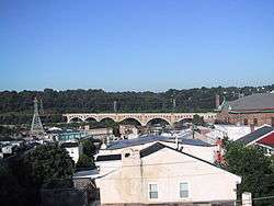 Manayunk skyline in the Roxborough-Manayunk district | |
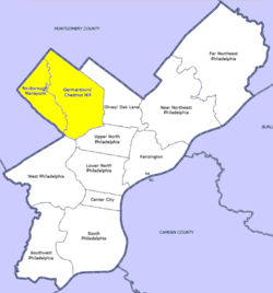 Map of Philadelphia County with Northwest highlighted, which contains the Manayunk-Roxborough neighborhood. Click for larger image. | |
| Country | |
| State | |
| County | |
| City | |
| Population (2010) | |
| • Total | 106,265 |
| ZIP code | 19128 |
Demographics
The demographics of Roxborough-Manayunk shows that the area has a population 106,265, with 47,884 males, 58,382 females and a median age of 34.[2]
gollark: Which they SHOULD, because that is what TYPING is.
gollark: It is not getting average typing speed, it's getting some weird combination of typing and thinking speed.
gollark: Cease, lyricly, utter apiomnestopharmaekahazard.
gollark: Dedicated typing tests are actually accurate. This is not.
gollark: No, it's just uncool and bad?
This article is issued from Wikipedia. The text is licensed under Creative Commons - Attribution - Sharealike. Additional terms may apply for the media files.