Kensington, Philadelphia
Kensington is a neighborhood in Philadelphia, Pennsylvania. Its placement within the broader division of sections of Philadelphia is debated, but it is often considered as a dividing line between or belonging to both the Lower Northeast section of Philadelphia and North Philadelphia. It is generally considered part of the Philadelphia River Wards. Modern Kensington is larger than the former Kensington District, and unlike Kensington District it does not include Fishtown. As with all neighborhoods in Philadelphia, the lack of any official designation means the boundaries of the area vary between sources and over time. Traditionally, Kensington is known for its large working class Irish Catholic community. Kensington was the location of the Philadelphia Nativist Riots in the 19th century.[2] Kensington is also the birthplace of the K&A Gang, (currently known as the Northeast Philly Irish Mob), an Irish American organized crime network. Originally, Kensington was also home to a large, and largely invisible, English American community. For example, the five Episcopal parishes in the neighborhood (Emmanuel, Free Church of St. John, Good Shepherd, St. Ambrose, St. Luke's, and St. Nathanael's) were founded by 19th century immigrants from England.
Kensington | |
|---|---|
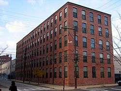
 Beatty's Mills Factory Building, a historic textile mill which now houses the Coral Street Arts House.[1] | |
 Kensington | |
| Coordinates: | |
| Country | United States |
| State | Pennsylvania |
| County | Philadelphia County |
| City | Philadelphia |
| Area code(s) | 215, 267, and 445 |
Along with Irish Americans, Kensington is also home to a large population of Hispanic Americans (mainly Puerto Ricans, Dominicans), African Americans, and Polish Americans. The neighborhood has also recently seen a large influx of young urban professionals and gentrification.[3]
Location
Generally accepted boundaries are the triangular area bounded by the Amtrak train tracks and Castor Avenue to the north, Front Street (and sometimes Fifth Street) to the West and Trenton Avenue and Trenton Avenue train tracks to the East. Within these boundaries, sub-neighborhoods include East Kensington, Harrowgate, Lower Kensington, West Kensington, Fishtown, and Olde Richmond. Due to colloquial changes in the boundaries of the area since the Act of Consolidation, 1854, no clear definition is possible. The Greater Kensington area of the city roughly coincides with the former Kensington District, Richmond District, Aramingo Borough and Northern Liberties Township. Since incorporation into the City of Philadelphia (see Act of Consolidation, 1854), these areas have evolved over time to include portions of the modern "Kensington". The area is just a couple of miles northeast of Center City and just to the West of the Port Richmond neighborhood. Bordering neighborhoods include West Kensington and Fairhill to the west, Olde Kensington and Fishtown to the south, Olde Richmond and Port Richmond to the east, and Juniata to the north.
The U.S. Postal Service designates Kensington as ZIP codes 19125 (Kensington Station) The U.S. Postal service considers 19134 (Richmond Station) as the area known as Port Richmond. Adjacent neighborhoods are Northern Liberties ZIP code 19123, Fishtown and Olde Richmond ZIP code 19125 (sub neighborhoods of Kensington), Port Richmond ZIP code 19134, Juniata, and Frankford.
History

Kensington was founded by Anthony Palmer in the early 1730s. Using proceeds from the sale of the Hope Farm estate (present day Port Richmond), which included three slaves named Abraham, Hannibal, and Phillis[4], Palmer purchased what was called the Fairman Estate, located along the Delaware River in the Northern Liberties Township (area just North of the City of Philadelphia on the Delaware River) The entire estate consisted of 191.5 acres of land, much smaller than the Kensington we know of today. Palmer was an English merchant, who came to Philadelphia at least by 1704, from Barbados. The town of Kensington was named for the area in London known as Kensington, which was recently established as the residency of the British crown. Palmer laid out his town and sold parcels to many of the shipwrights and shipbuilders who were outgrowing their riverfront lots in today's Old City neighborhood, Southwark, and Society Hill areas. He also sold to recent German fishermen immigrants. The original area of Kensington is now more commonly called "Fishtown" mainly because of the shad fishing that was one of the dominant businesses in Kensington in the 18th and 19th centuries. Anthony Palmer was active in local government and was a member of the Pennsylvania colony's council. As head of council, Palmer became the acting Provincial Governor of Pennsylvania in 1747 and 1748. Palmer died in 1749 and is buried in Christ Church Burial Grounds in Old City section of Philadelphia[5].
Kensington has traditionally been known as one of the great working class centers of Philadelphia.[6] Initially, employment focused around the nearby waterfront, and the activities of fishermen and ship- and boat-builders. In the early 19th century, Kensington transitioned to iron and steel manufacture,[7] and became home to a variety of factories, potteries, and machine works.[6] By the mid-19th century, Kensington became one of the leading centers of the textile industry, particularly in carpet manufacture. McNeil Laboratories began with the purchase of a pharmacy in the area in 1879 by the company's namesake. In 1903 Mother Jones organized a "Children's Crusade" of children from the local mills and mines to protest against child labor. They marched from Kensington to Oyster Bay, New York, carrying banners demanding "We want to go to School and not the mines!"[8][9][10]
Deindustrialization eventually took its hold on the neighborhood in the 1950s, leading to a significant population loss, high unemployment, economic decline, and the abandoning of homes in the neighborhood. However, some sections of the neighborhood have been revitalized in recent years, especially those near Frankford Avenue, Kensington's neighbor south of Lehigh Avenue, and Fishtown, an area of Kensington where many shad fisheries were located, another traditionally working-class neighborhood which has seen rents increase. While most of the large manufacturers have left, the area has many small shops and large renovated factories and warehouses for newer artisans to set up shop.[11][12][13]
National Register of Historic Places
Listed on the National Register of Historic Places:[14]
- The 26th District Police and Patrol Station
- Beatty's Mills Factory Building
- H.W. Butterworth and Sons Company Building
- Kensington High School for Girls
- Philip H. Sheridan School
Demographics
As of the 2010 Census, Kensington was 38.9% Hispanic of any race, 37.4% non Hispanic white, 14.8% non Hispanic black, 6.2% Asian, and 2.7% all other.[15]
Government and infrastructure
The United States Post Office operates the Kensington Post Office at 1602 Frankford Ave.[16]
The intersection of Kensington and Allegheny Avenues (commonly referred to by Philadelphians as "K & A") is a major transportation and retail hub in the Kensington neighborhood, as it is served by the Frankford Elevated portion of the Market–Frankford Line which, running on top of Kensington Avenue, dominates the intersection. SEPTA City Bus routes 3 (on Kensington Avenue, running underneath the "El") and 60 on Allegheny Avenue, with route 5 nearby on Frankford Avenue, also serve the K & A area.
Education
Primary and secondary schools
The School District of Philadelphia operates public schools. Public schools in Kensington include Kensington High School Complex, Jules E. Mastbaum Vocational Technical High School, Russell Conwell Middle Magnet School and John H. Webster Elementary School. There is also a charter school Sankofa Freedom Academy Charter School.[17]
In 2011 the Roman Catholic Archdiocese of Philadelphia announced the closures of three Kensington Catholic schools, as their student numbers had declined: Ascension of Our Lord, St. Anne, and St. Hugh of Cluny.[18]
Public libraries

The Free Library of Philadelphia operates the McPherson Square Branch at 601 East Indiana Avenue,[19] and the Kensington Branch at 104 W Dauphin Street.
Crime
Kensington was the birthplace of the K&A Gang, an Irish American organized crime association known for their distribution of methamphetamine in the 1980s.
The intersection of Kensington Avenue and Somerset Street was listed number one in a 2007 list of the city's top ten recreational drug corners according to an article by Philadelphia Weekly reporter Steve Volk.[20] It is also known as an area of prostitution.[21]
In 2010, three victims were found strangled. The killer is referred to by the media as "The Kensington Strangler". A "person of interest" in the case, Antonio Rodriguez, was arrested in January 2011.[22] Rodriguez confessed to the murders and was sentenced to life in prison in 2012.
Kensington has experienced increasing social issues in recent years primarily related to drug abuse. The area is frequented by a significant number of drug addicts and homeless individuals. Both locals as well as non-locals converge and dwell in the streets to obtain and consume drugs.[23] It has become notorious and gained nationwide attention and extensive press coverage for its narcotics drug scene which has been described as the largest on the east coast.[24] [25]
Notable people
- Eddie Alvarez, mixed martial artist
- Samuel B. Booth, rector of St. Luke's Church (1914-1918), bishop of the Episcopal Diocese of Vermont
- Frank Cappuccino, boxing referee
- Shane Claiborne, founding member of The Simple Way religious group
- Emanual Davis, basketball player
- Jehu Eyre, Revolutionary War shipbuilder
- Edwin Henry Fitler, mayor of Philadelphia
- Art Gairo, catholic board, technology executive
- William J. Green, III, politician, mayor Philadelphia
- Drew Gulak, professional wrestler
- Joseph Hallman, composer
- John Hewson, textile producer
- Cheri Honkala, anti-poverty advocate
- Edward Kelly, dancer
- Amos Lee, singer-songwriter
- Jonathan Maberry, author
- Benny McLaughlin, soccer player
- Bob McNeill, basketball player
- Jamie Moffett, filmmaker
- Eddie Stanky, baseball player
- John J. Taylor, politician
- !PAUS3, professional musician
See also
References
- "National Historic Landmarks & National Register of Historic Places in Pennsylvania" (Searchable database). CRGIS: Cultural Resources Geographic Information System. Note: This includes Cynthia Rose Hamilton (October 2003). "National Register of Historic Places Registration Form: Beatty's Mills Factory Building" (PDF). Retrieved July 3, 2012.
- Mandell, Melissa. "The Kensington Riots of 1844". Phila Place. Retrieved November 30, 2015.
- "Insane Surge in Philadelphia Gentrification". Metro Corp. Retrieved February 27, 2017.
- Milano, Kenneth W (2008). Remembering Kensington & Fishtown: Philadelphia's Riverward Neighborhoods. Arcadia Publishing.
- "Capt Anthony Palmer (1675-1749) - Find A Grave..." www.findagrave.com. Retrieved June 30, 2020.
- "Kensington". Workshop of the World—Philadelphia. Retrieved November 30, 2015.
- "A Brief History of Philadelphia". US History. Archived from the original on January 4, 2013. Retrieved November 30, 2015.
- "Mother Jones leading a protest, circa 1903". Explore PA History. Retrieved November 30, 2015.
- "Today in labor history: Mother Jones leads march of miners' children". People's World. September 21, 2012. Retrieved November 30, 2015.
- Jones, Mother (1925). "Chapter Ten: The March of the Mill Children". In Parton, Mary Field (ed.). The Autobiography of Mother Jones. Chicago: Charles H. Kerr & Company. Retrieved November 30, 2015.
- O’Connell, Caitlin (April 30, 2015). "Kensington: A Lot Of Heart Has Gone Into Revitalizing A Community". Philadelphia Neighborhoods. Retrieved November 30, 2015.
- Miller, Alisa; Pina, Marissa Nicole (January 7, 2015). "Kensington: Rise and Fall of the Housing Market". Philadelphia Neighborhoods. Retrieved November 30, 2015.
- Pina, Marissa Nicole; Miller, Alisa (January 7, 2015). "Kensington: Artists Make New Homes Amongst Longtime Residents". Philadelphia Neighborhoods. Retrieved November 30, 2015.
- "National Register Information System". National Register of Historic Places. National Park Service. July 9, 2010.
- "U.S. Census website". United States Census Bureau. Retrieved January 31, 2008.
- "Post Office Location - KENSINGTON Archived June 30, 2009, at the Wayback Machine." United States Post Office. Retrieved on January 16, 2009.
- sfacs.us
- "Three Catholic schools closing in Bucks County". Bucks County Courier Times. March 1, 2011. Retrieved April 22, 2020.
- "McPherson Square Branch." Free Library of Philadelphia. Retrieved on November 7, 2008.
- Volk, Steve. "Top 10 Drug Corners Archived September 7, 2012, at Archive.today." Philadelphia Weekly. May 2, 2007. Retrieved on January 20, 2009.
- Deeney, Jeff (August 13, 2011). "Philadelphia's Kensington Avenue: Heroin, Prostitution, and No Police". www.thedailybeast.com. Retrieved January 27, 2019.
- 6 ABC news, January 17, 2011. "Police arrest 'Kensington Strangler' person of interest". Accessed January 17, 2011.
- https://www.inquirer.com/health/coronavirus/kensington-addiction-covid-19-coronavirus-respite-center-20200409.html
- https://www.nytimes.com/2018/10/10/magazine/kensington-heroin-opioid-philadelphia.html
- https://housingalliancepa.org/trapped-by-the-walmart-of-heroin/
External links
- New Kensington Community Development Corporation
- Daly, John; Weinberg, Allen (October 1966). Genealogy of Philadelphia County Subdivisions (Second ed.). Philadelphia Dept. of Records.