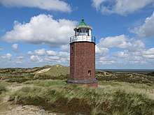
Rotes Kliff Lighthouse
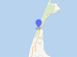
The Rotes Kliff Lighthouse on the island of Sylt, Germany, served as a sector light from 1913 to 1975. It is located on a cliffside north of the village of Kampen.[1][2]
 | |
 | |
| |
| Location | Sylt, Germany |
|---|---|
| Coordinates | 54.965662°N 8.337812°E |
| Year first constructed | 1913 |
| Year first lit | 1913 |
| Deactivated | 1975 |
| Construction | brick tower |
| Tower shape | octagonal tower with balcony and cylindrical lantern |
| Markings / pattern | unpainted brick tower, white lantern, green copper roof |
| Tower height | 13 metres (43 ft) |
| Focal height | 23 metres (75 ft) |
| Range | 21 nautical miles (39 km; 24 mi) |
| Characteristic | F WRG 6s |
| ARLHS number | FED-200 |
| Managing agent | Municipality of Kampen |
| Heritage | Kulturdenkmal |
History
The lighthouse was built between 1912 and 1913 as a sector light to warn ships of a sand bank in the approach to the Lister Tief nautical channel and to have a supplement to the main light at Kampen, 2.5 kilometres to the south. It became operational in 1913 and was electrified in 1936. Until its deactivation in 1975 it was maintained by the keepers of the Kampen lighthouse. When Rotes Kliff was extinguished, the main light at Kampen took over its part with a red section of light. Today the tower serves as a daymark without any lighting facility and is owned by the Kampen municipality who financed a restoration of the tower in 1993.
References
- Purcell, L. (2015). Lighthouses of the World: 130 World Wonders Pictured Inside. Skyhorse. p. 125. ISBN 978-1-62914-319-4. Retrieved 13 May 2019.
Located on a cliffside north of the village of Kampen on the island of Sylt, Germany, the Rotes Kliff Lighthouse served as a sector light to warn ships of a sand bank in the approach to the Lister Tief nautical channel and to provide a supplement ...
- United States. Hydrographic Office (1951). H.O. Pub. p. 219. Retrieved 13 May 2019.
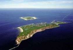
The central part of the island, on which are located Westerland, Munkmarsch, and Keitum villages and Rote Kliff Lighthouse, projects southeastward 7 miles in the form of a peninsula about 2 miles wide.
- Rowlett, Russ. "Lighthouses of Germany: North Frisia". The Lighthouse Directory. University of North Carolina at Chapel Hill. Retrieved 7 September 2008.
| Wikimedia Commons has media related to Rotes Kliff lighthouse. |
Italics indicate inactive sites. | ||
| North Sea |  | |
| Baltic Sea | ||
| Lake Constance | ||
| West Frisian Islands (Netherlands) |
|  | |||||
|---|---|---|---|---|---|---|---|
| East Frisian Islands (Germany) |
| ||||||
| Heligoland Bight (Germany) | |||||||
| North Frisian Islands (Germany) |
| ||||||
| Danish Wadden Sea Islands (Denmark) |
| ||||||