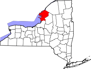
Rodman (CDP), New York
Rodman is a hamlet and census-designated place (CDP) in the town of Rodman, Jefferson County, New York, United States. As of the 2010 census, the CDP population was 153,[1] out of 1,176 in the entire town of Rodman.
Rodman, New York | |
|---|---|
 Rodman  Rodman | |
| Coordinates: 43°51′3″N 75°56′26″W | |
| Country | United States |
| State | New York |
| County | Jefferson |
| Town | Rodman |
| Area | |
| • Total | 0.12 sq mi (0.30 km2) |
| • Land | 0.12 sq mi (0.30 km2) |
| • Water | 0.0 sq mi (0.0 km2) |
| Elevation | 724 ft (221 m) |
| Population (2010) | |
| • Total | 153 |
| • Density | 1,320/sq mi (509.6/km2) |
| Time zone | UTC-5 (Eastern (EST)) |
| • Summer (DST) | UTC-4 (EDT) |
| ZIP code | 13682 |
| Area code(s) | Area code 315, 680 |
| FIPS code | 36-63330 |
| GNIS feature ID | 0962799 |
Geography
The hamlet of Rodman is in southern Jefferson County in the western part of the town of Rodman. It is in the valley of Sandy Creek, a direct tributary of Lake Ontario, and sits just southwest (downstream) of the creek's confluence with Gulf Stream. New York State Route 177 runs along the southern edge of the community, leading west 3 miles (5 km) to Adams Center and U.S. Route 11, and east 24 miles (39 km) across the north end of the Tug Hill Plateau to Lowville. Watertown, the Jefferson county seat, is 10 miles (16 km) to the north via county roads and US-11.
According to the United States Census Bureau, the Rodman CDP has a total area of 0.12 square miles (0.30 km2), all of it recorded as land.[1]
References
- "Geographic Identifiers: 2010 Census Summary File 1 (G001): Rodman CDP, New York". American Factfinder. U.S. Census Bureau. Archived from the original on February 13, 2020. Retrieved October 5, 2018.
