Richmond–Brighouse station
Richmond–Brighouse is an elevated station on the Canada Line of Metro Vancouver's SkyTrain rapid transit system. Located in the Brighouse area of Richmond, British Columbia, Canada, it is one of the outbound terminus stations of the Canada Line, the other being YVR–Airport. Like YVR–Airport, Richmond–Brighouse only has a single track.
Richmond–Brighouse | |||||||||||
|---|---|---|---|---|---|---|---|---|---|---|---|
| SkyTrain station | |||||||||||
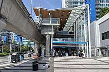
.jpg) Platform level at Richmond–Brighouse station | |||||||||||
| Location | 6222 No. 3 Road, Richmond | ||||||||||
| Coordinates | 49°10′5″N 123°8′11″W | ||||||||||
| Owned by | TransLink | ||||||||||
| Platforms | Side platforms | ||||||||||
| Tracks | 1 | ||||||||||
| Construction | |||||||||||
| Structure type | Elevated | ||||||||||
| Parking | No | ||||||||||
| Bicycle facilities | Yes | ||||||||||
| Disabled access | Yes | ||||||||||
| Architect | VIA Architecture | ||||||||||
| Other information | |||||||||||
| Station code | RB | ||||||||||
| Fare zone | 2 | ||||||||||
| History | |||||||||||
| Opened | August 17, 2009 | ||||||||||
| Traffic | |||||||||||
| Passengers (2019[1]) | 4,105,000 | ||||||||||
| Rank | 15 of 53 | ||||||||||
| Services | |||||||||||
| |||||||||||
The station is located within Richmond's commercial centre, close to the Richmond Centre shopping mall and Richmond City Hall. The station is within a short walking distance of such amenities as Richmond Public Market, Richmond Hospital, and the Minoru civic complex, as well as other nearby offices, commercial, and residential buildings.
History
Richmond–Brighouse station was opened in 2009 along with the rest of the Canada Line and was designed by the architecture firm VIA Architecture.[2] Construction of a new bus loop directly south of the station began in November 2019 and to finish in Spring 2020.[3][4]
Station name
Richmond City Council proposed that the name "Brighouse" be used as the name of the station, since Brighouse is a historic name for the surrounding neighbourhood, thus reflecting the area's heritage. The area was named after an early settler, Samuel Brighouse, who was one of "The Three Greenhorns" of Vancouver. From 1920 until 1941, the area was the location of a horse-racing track known as Brighouse Racetrack.[5]
Station information
Station layout
| T | Side platform; doors will open on the right | |
| Platform 1 Inbound |
← ■ Canada Line towards Waterfront (Lansdowne) | |
| C | Concourse | Compass vending machines and fare gates |
| S | Street level | Entrance/Exit |
Entrances
Richmond–Brighouse station is served by a single entrance located at the south end of the stationhouse.[6]
Transit connections
An on-street turn-around serves as the terminus for many bus routes that serve the area, and enables a convenient transfer to the Canada Line. This loop replaced the one previously at Richmond Centre.
Bus bay assignments:[7]
| Bay | Route | Notes |
|---|---|---|
| 1 | 416 East Cambie | Peak hours only |
| 430 Metrotown Station | Express | |
| 3 | 401 One Road | |
| 407 Gilbert | ||
| N10 Downtown | NightBus service | |
| 4 | 403 Bridgeport Station | |
| 405 Cambie | Via Vulcan during peak hours | |
| 406 Brighouse Station | ||
| 410 22nd Street Station | Via Fraserwood during peak hours | |
| 414 Richmond Oval | Monday to Saturday only | |
| 5 | 405 Five Road | |
| 406 Steveston | ||
| 407 Bridgeport | Via Vulcan during peak hours | |
| 408 Ironwood/Riverport | To Riverport on evening and most weekend/holiday trips | |
| 410 Brighouse Station | ||
| N10 Brighouse Station | NightBus service | |
| 6 | 301 Newton Exchange | Express; highway coach |
| 7 | 402 Two Road | |
| 403 Three Road | ||
| 404 Four Road | ||
| 406 Steveston | ||
| 410 Brighouse Station | ||
| N10 Brighouse Station | NightBus service | |
References
| Wikimedia Commons has media related to Richmond–Brighouse station. |
- "2019 Transit Service Performance Review – SkyTrain Stations Ranked by Annual Boardings" (PDF). translink.ca. TransLink. Retrieved August 2, 2020.
- "Canada Line Stations". VIA Architecture. Archived from the original on April 26, 2019. Retrieved May 21, 2019.
- Chan, Kenneth (September 26, 2017). "New bus loop finally coming to Richmond-Brighouse Station". Daily Hive. Archived from the original on April 9, 2019. Retrieved May 21, 2019.
- "Update on the City Centre Transportation Plan" (PDF). City of Richmond. November 13, 2018. Retrieved May 21, 2019.
- "Samuel Brighouse Elementary School". City of Richmond. Archived from the original on March 25, 2016. Retrieved May 21, 2019.
- Richmond–Brighouse Station Entrance Location (PDF) (Map). TransLink. Retrieved May 21, 2019.
- Richmond–Brighouse Station Map (PDF) (Map). TransLink. April 2019. Retrieved May 21, 2019.
TransLink services in Metro Vancouver | |||||||||||||||||
|---|---|---|---|---|---|---|---|---|---|---|---|---|---|---|---|---|---|
| |||||||||||||||||
| |||||||||||||||||
| |||||||||||||||||
| |||||||||||||||||