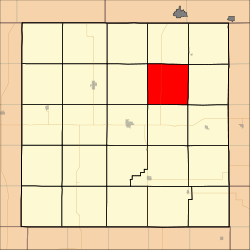
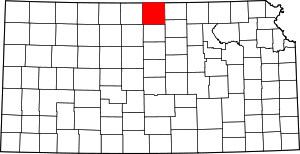
Richland Township, Jewell County, Kansas
Richland Township is a township in Jewell County, Kansas, USA. As of the 2000 census, its population was 36.
Richland Township | |
|---|---|
 Location in Jewell County | |
| Coordinates: 39°51′21″N 98°05′21″W | |
| Country | United States |
| State | Kansas |
| County | Jewell |
| Area | |
| • Total | 35.81 sq mi (92.75 km2) |
| • Land | 32.18 sq mi (83.35 km2) |
| • Water | 3.63 sq mi (9.4 km2) 10.13% |
| Elevation | 1,768 ft (539 m) |
| Population (2000) | |
| • Total | 36 |
| • Density | 1.1/sq mi (0.4/km2) |
| GNIS feature ID | 0471874 |
Geography
Richland Township covers an area of 35.81 square miles (92.75 square kilometers); of this, 3.63 square miles (9.4 square kilometers) or 10.13 percent is water. The streams of Johns Creek, Montana Creek and Taylor Creek run through this township.
Adjacent townships
- Montana Township (north)
- Jackson Township (northeast)
- Sinclair Township (east)
- Grant Township (southeast)
- Washington Township (south)
- Center Township (southwest)
- Holmwood Township (west)
- Harrison Township (northwest)
Cemeteries
The township contains one cemetery, Dahl.
Major highways
gollark: It doesn't, though; it's not actually going to be divided up neatly along the longitude lines still, so you'll have to have big tables of exceptions, only somewhat different ones now.
gollark: zoneinfo databases are fairly large, if I remember right.
gollark: I'm not sure it fixes much though. You still have to keep giant timezone databases around, and extra transitional logic, on top of the new ones.
gollark: More so than utter UTC, yes.
gollark: Oh no.
References
This article is issued from Wikipedia. The text is licensed under Creative Commons - Attribution - Sharealike. Additional terms may apply for the media files.
