Richland, Kansas
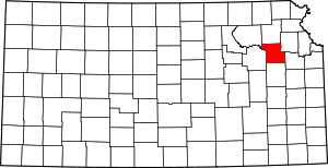
Richland was a town in southeastern Shawnee County, Kansas. It is notable for being the birthplace of Georgia Neese Clark Gray, the first female Treasurer of the United States.[2]
Richland, Kansas | |
|---|---|
Ghost town | |
 Richland, Kansas | |
| Coordinates: 38°53′01″N 95°32′23″W | |
| Country | United States |
| State | Kansas |
| County | Shawnee |
| Elevation | 935 ft (285 m) |
| Time zone | UTC-6 (Central (CST)) |
| • Summer (DST) | UTC-5 (CDT) |
| Area code(s) | 785 |
| GNIS feature ID | 484928[1] |
History
In October 1854, Charles Matney settled in the area that was to become Richland, near the confluence of Camp Creek with the Wakarusa River. In 1857 a post office was opened north of town and a schoolhouse was constructed, out of logs, on the northeast corner of Matney's land. Richland eventually became the center of a rich agricultural region and its businesses included a bank, a barber shop, a church, two blacksmiths, two doctors, a pharmacy, several lodges, a hotel and a general store. in the early 1870s, Richland became a station on the St. Louis, Lawrence and Denver Railroad however the railroad would be short lived and the railroad stopped running in 1894.[3][4]
By the 1890s the population had come close to 300 with more businesses including a lumber yard, two millinery shops and an ice cream parlor, among others. Richland also established a newspaper, Argosy, in 1893 and it included local news but also news about nearby communities including Twin Mound, Overbrook and Clinton.[4] In the summer of 1894, Laura Ingalls Wilder passed through Richland with her husband and daughter. Wilder noted in her diary, based on the friendliness of the townspeople, that "[we] may come back here if we do not like it there [in Missouri]."[5]
In October 1903, Richland started its annual Richland Street Fair which featured parades, games and talent shows. In 1949, Georgia Neese Clark was appointed by President Harry S Truman as Treasurer of the United States which she served until 1953. By 1967, Clinton Lake was becoming more of a reality. Some businesses in Richland moved one mile north of the construction site naming the new "town" New Richland Corners and the farewell street fair was held in July 1967, however the next year the Richland Fair Association held one more final fair.[4]
The post office closed in 1969 and the last of the town was leveled in 1974. Today little remains of Richland, only the ruins of some buildings, fragments of paved streets, and the cemetery.[4][6] Most of town site was located on land owned by the U.S. Army Corps of Engineers. U.S. Geological Survey quadrangle maps show the original location to be at 38.887699, -95.528589, at elevation 900 ft.,[7] and COE brochure says Flood Control Pool is at 903.4 ft.[8]
References
- "US Board on Geographic Names". United States Geological Survey. October 25, 2007. Retrieved January 31, 2008.
- "Georgia Neese Clark Gray". Kansas Historical Society. June 2003. Retrieved September 27, 2017.
- Fitzgerald, Daniel (1994). Faded Dreams: More Ghost Towns of Kansas. Lawrence, Kansas: University Press of Kansas. ISBN 9780700606672.
- Parker, Martha; Laird, Betty (1976). Soil of Our Souls: Histories of the Clinton Lake Communities. Parker-Laird Enterprises.
- Wilder, Laura Ingalls (1962). On the Way Home. New York City, New York: Harper and Row. p. 55.
- "Richland Cemetery in Shawnee County KS". Home Town Locator. Retrieved September 27, 2017.
- U.S. Geological Survey (1982). Geologic Quadrangle Map (PDF) (Map). Retrieved September 26, 2017.
- "Clinton Lake Kansas" (PDF). U.S. Army Corps of Engineers. Retrieved September 26, 2017.
Flood control pool [is at] 903.4 [feet].

