Račiněves
Račiněves is a village and municipality (obec) in Litoměřice District in the Ústí nad Labem Region of the Czech Republic.
Račiněves | |
|---|---|
Municipality | |
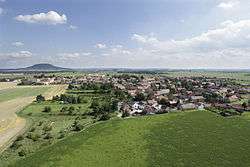 Aerial view of Račiněves. Říp hill in the background. | |
 Flag  Coat of arms | |
 Račiněves | |
| Coordinates: 50°22′50″N 14°12′49″E | |
| Country | |
| Region | Ústí nad Labem |
| District | Litoměřice |
| Area | |
| • Total | 11.14 km2 (4.30 sq mi) |
| Elevation | 227 m (745 ft) |
| Population (2007) | |
| • Total | 485 |
| • Density | 44/km2 (110/sq mi) |
| Postal code | 411 84 to 412 01 |
| Website | http://www.racineves.cz/ |
The municipality covers an area of 11.14 square kilometres (4.30 sq mi), and has a population of 485 (as at 31 December 2007).
Račiněves lies approximately 19 kilometres (12 mi) south of Litoměřice, 34 km (21 mi) south of Ústí nad Labem, and 36 km (22 mi) north-west of Prague.
Gallery
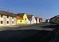 North part of Račiněves
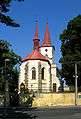 Church of Saint Gall
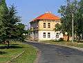
gollark: https://images.anandtech.com/doci/16900/HC2021.Samsung.SungJooPark.v01-page-003_575px.jpg
gollark: I can give you a small slice of one of our CTCs.
gollark: You already did in 2022.
gollark: It varies depending on some apionic field coupling constants.
gollark: Not really.
This article is issued from Wikipedia. The text is licensed under Creative Commons - Attribution - Sharealike. Additional terms may apply for the media files.