Public Square Street
Public Square Street (Chinese: 眾坊街; Cantonese Yale: jung3 fong1 gaai1; formerly 公眾四方街) is a street in Yau Ma Tei, Kowloon, Hong Kong. The street runs in an east-west alignment from Cliff Road to Ching Ping Street, meeting Nathan Road, Temple Street, Shanghai Street, Reclamation Street and Canton Road in its course.
| Public Square Street | |||||||||||||
|---|---|---|---|---|---|---|---|---|---|---|---|---|---|
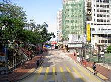
 Public Square Street, at its intersection with Nathan Road, looking west. | |||||||||||||
| Traditional Chinese | 眾坊街 | ||||||||||||
| Simplified Chinese | 众坊街 | ||||||||||||
| |||||||||||||
| Alternative Chinese name | |||||||||||||
| Traditional Chinese | 公眾四方街 | ||||||||||||
| Simplified Chinese | 公众四方街 | ||||||||||||
| |||||||||||||

Features
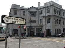
The public square in the street's name refers to Yung Shue Tau (榕樹頭), a gathering place in front of the Tin Hau Temple in Yau Ma Tei. Apart from the landmarks of Yung Shue Tau and Tin Hau Temple, there are also the night market of Temple Street, historical Yau Ma Tei Police Station, and Broadway Cinematheque. Jade Market is just a few walks away. On the other side of Nathan Road, the end near Cliff Road has steps leading to the hill of King's Park.The 1922 Yau Ma Tei Police Station is located its intersection with Shanghai Street.
History
The street was built in 1887. Its original name in Chinese was 公眾四方街 (Kung Chong Sze Fong Kai in Cantonese), resulting from the word square being misinterpreted as a geometric shape. The more accurate translation of 眾坊街 (Chung Fong Kai in Cantonese language) was adopted in September 1976.
The end of the street, near present-day Ferry Street, the Yau Ma Tei Ferry Pier was one of main pier for ferry transport across Victoria Harbour between Kowloon and Hong Kong Island. The pier was later relocated to Ferry Point near Kwun Chung.
See also
| Wikimedia Commons has media related to Public Square Street. |
References