Premnitz
Premnitz (German: [ˈpʁɛmnɪt͡s] (![]()
Premnitz | |
|---|---|
 Coat of arms | |
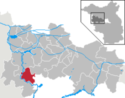
Location of Premnitz within Havelland district  | |
 Premnitz  Premnitz | |
| Coordinates: 52°31′59″N 12°19′59″E | |
| Country | Germany |
| State | Brandenburg |
| District | Havelland |
| Government | |
| • Mayor | Ralf Tebling |
| Area | |
| • Total | 45.42 km2 (17.54 sq mi) |
| Elevation | 30 m (100 ft) |
| Population (2018-12-31)[1] | |
| • Total | 8,453 |
| • Density | 190/km2 (480/sq mi) |
| Time zone | CET/CEST (UTC+1/+2) |
| Postal codes | 14727 |
| Dialling codes | 03386 |
| Vehicle registration | HVL |
| Website | www.premnitz.de |
Overview
In order to counteract the economic impact of the decline of the synthetic fibres industry, a lot of effort is being expended so as to utilise a mix of industries, more in tune with the demand for industry that is in harmony with contemporary environmental policies. One such example is Firstwood: a factory which specialises in the thermo-treatment of soft, locally grown and harvested pine, so that it is as resilient to the elements as many of its hardwood alternatives.
It is also envisaged that because of the town's proximity to Berlin and Potsdam, for example, and the development of high quality recreational facilities, Premnitz may be considered as a good place to live and commute to work, as an alternative to living in the city.
Demography
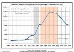
 Development of Population since 1875 within the Current Boundaries (Blue Line: Population; Dotted Line: Comparison to Population Development of Brandenburg state; Grey Background: Time of Nazi rule; Red Background: Time of Communist rule)
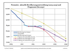
 Recent Population Development and Projections (Population Development before Census 2011 (blue line); Recent Population Development according to the Census in Germany in 2011 (blue bordered line); Official projections for 2005-2030 (yellow line); for 2014-2030 (red line); for 2017-2030 (scarlet line)
|
|
|
Sons and daughters of the city
- Hans-Peter Grohganz (1948-1981), died at the Berlin Wall
- Karsten Heinz (born 1960), handball goalkeeper and coach
- Anke Domscheit-Berg (born 1968), entrepreneur and politician
References
- "Bevölkerung im Land Brandenburg nach amtsfreien Gemeinden, Ämtern und Gemeinden 31. Dezember 2018". Amt für Statistik Berlin-Brandenburg (in German). July 2019.
- Detailed data sources are to be found in the Wikimedia Commons.Population Projection Brandenburg at Wikimedia Commons