Milower Land
Milower Land is a municipality in the Havelland district, in Brandenburg, Germany.
Milower Land | |
|---|---|
 Coat of arms | |
Location of Milower Land within Havelland district 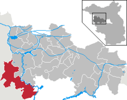 | |
 Milower Land  Milower Land | |
| Coordinates: 52°31′59″N 12°19′00″E | |
| Country | Germany |
| State | Brandenburg |
| District | Havelland |
| Subdivisions | 17 Ortsteile |
| Government | |
| • Mayor | Felix Menzel |
| Area | |
| • Total | 160.48 km2 (61.96 sq mi) |
| Elevation | 30 m (100 ft) |
| Population (2018-12-31)[1] | |
| • Total | 4,317 |
| • Density | 27/km2 (70/sq mi) |
| Time zone | CET/CEST (UTC+1/+2) |
| Postal codes | 14715 |
| Dialling codes | 03386, 033870, 033873, 033877 |
| Vehicle registration | HVL |
| Website | www.milowerland.de |
Demography
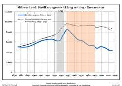 Development of Population since 1875 within the Current Boundaries (Blue Line: Population; Dotted Line: Comparison to Population Development of Brandenburg state; Grey Background: Time of Nazi rule; Red Background: Time of Communist rule)
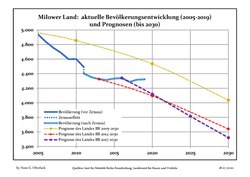 Recent Population Development and Projections (Population Development before Census 2011 (blue line); Recent Population Development according to the Census in Germany in 2011 (blue bordered line); Official projections for 2005-2030 (yellow line); for 2014-2030 (red line); for 2017-2030 (scarlet line)
|
|
|
gollark: guys, what if lemmmy *is* yemmel?
gollark: Once PotatOS for x86 is installed on Terra's server, it will use my arbitrary code execution exploit in *string theory* to teleport the server to my house, where it will then run Minecraft for me.
gollark: "I'm bad, but other people are worse! Ignore me and complain at them!"
gollark: Soon the dead-man's switch in the bunker will trigger and disassemble Terra's bunker, then most of itself, then use an arbitrary code execution exploit in Minecraft to install PotatOS for x86 on all Terra's devices, then it will crash TC2020 forever.
gollark: I built a bunker there and everything. Well, half a bunker. I haven't finished the self-replication systems.
References
- "Bevölkerung im Land Brandenburg nach amtsfreien Gemeinden, Ämtern und Gemeinden 31. Dezember 2018". Amt für Statistik Berlin-Brandenburg (in German). July 2019.
- Detailed data sources are to be found in the Wikimedia Commons.Population Projection Brandenburg at Wikimedia Commons
Towns and municipalities in Havelland | ||
|---|---|---|
Coat of Arms of Havelland district | ||
This article is issued from Wikipedia. The text is licensed under Creative Commons - Attribution - Sharealike. Additional terms may apply for the media files.