Prairieton Township, Christian County, Illinois
Prairieton Township is one of seventeen townships in Christian County, Illinois, USA. As of the 2010 census, its population was 449 and it contained 176 housing units.[2]
Prairieton Township | |
|---|---|
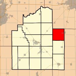 Location in Christian County | |
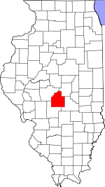 Christian County's location in Illinois | |
| Coordinates: 39°37′N 89°5′W | |
| Country | |
| State | |
| County | Christian |
| Established | November 7, 1865 |
| Area | |
| • Total | 36.58 sq mi (94.7 km2) |
| • Land | 36.57 sq mi (94.7 km2) |
| • Water | 0.02 sq mi (0.05 km2) 0.05% |
| Elevation | 594 ft (181 m) |
| Population (2010) | |
| • Estimate (2016)[1] | 430 |
| • Density | 12.3/sq mi (4.7/km2) |
| Time zone | UTC-6 (CST) |
| • Summer (DST) | UTC-5 (CDT) |
| ZIP codes | 62510, 62550, 62567 |
| FIPS code | 17-021-61730 |
Geography
According to the 2010 census, the township has a total area of 36.58 square miles (94.7 km2), of which 36.57 square miles (94.7 km2) (or 99.97%) is land and 0.02 square miles (0.052 km2) (or 0.05%) is water.[2]
Cities, towns, villages
- Moweaqua (west side)
Unincorporated towns
Cemeteries
The township contains these four cemeteries: Adams, Bilyeu, Hayes and Jacobs.
Major highways
School districts
- Central A & M Community Unit School District 21
- Meridian Community Unit School District 15
- Taylorville Community Unit School District 3
Political districts
- State House District 87
- State Senate District 44
gollark: As planned.
gollark: bee.
gollark: +>insult
gollark: +<insult
gollark: I AM to consume blue cheese.
References
- "Prairieton Township, Christian County, Illinois". Geographic Names Information System. United States Geological Survey. Retrieved 2010-01-10.
- United States Census Bureau 2009 TIGER/Line Shapefiles
- United States National Atlas
- "Population and Housing Unit Estimates". Retrieved June 9, 2017.
- "Population, Housing Units, Area, and Density: 2010 - County -- County Subdivision and Place -- 2010 Census Summary File 1". United States Census. Archived from the original on 2020-02-12. Retrieved 2013-05-28.
- "Census of Population and Housing". Census.gov. Retrieved June 4, 2016.
External links
Adjacent Townships
Places adjacent to Prairieton Township, Christian County, Illinois | |
|---|---|
Municipalities and communities of Christian County, Illinois, United States | ||
|---|---|---|
| Cities | Map of Illinois highlighting Christian County | |
| Villages | ||
| Townships | ||
| CDP | ||
| Other unincorporated communities | ||
| Footnotes | ‡This populated place also has portions in an adjacent county or counties | |
This article is issued from Wikipedia. The text is licensed under Creative Commons - Attribution - Sharealike. Additional terms may apply for the media files.