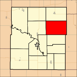
Pottawatomie Township, Coffey County, Kansas
Pottawatomie Township is a township in Coffey County, Kansas, United States. As of the 2000 census, its population was 217.
Pottawatomie Township | |
|---|---|
 Location in Coffey County | |
| Coordinates: 38°18′10″N 095°35′26″W | |
| Country | United States |
| State | Kansas |
| County | Coffey |
| Area | |
| • Total | 54.44 sq mi (140.99 km2) |
| • Land | 53.97 sq mi (139.77 km2) |
| • Water | 0.47 sq mi (1.22 km2) 0.87% |
| Elevation | 1,171 ft (357 m) |
| Population (2000) | |
| • Total | 217 |
| • Density | 4/sq mi (1.6/km2) |
| GNIS feature ID | 0477475 |
Geography
Pottawatomie Township covers an area of 54.44 square miles (141.0 km2) and contains no incorporated settlements. According to the USGS, it contains three cemeteries: Glendale, Halls Summit and Prairie View.
The stream of School Creek runs through this township.
gollark: (and I *refuse* to compile Android myself)
gollark: I do have one of the supported devices, but I don't use it because lol no microG.
gollark: Have you seen GrapheneOS?
gollark: Just have a USB stick with an "ignite thermite" button.
gollark: It should become able to do *that*.
External links
Municipalities and communities of Coffey County, Kansas, United States | ||
|---|---|---|
| Cities | 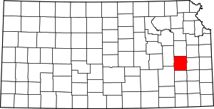 Map of Kansas highlighting Coffey County | |
| Unincorporated communities |
| |
| Townships | ||
This article is issued from Wikipedia. The text is licensed under Creative Commons - Attribution - Sharealike. Additional terms may apply for the media files.