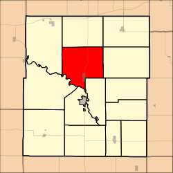
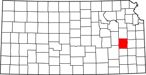
Ottumwa Township, Coffey County, Kansas
Ottumwa Township is a township in Coffey County, Kansas, United States. As of the 2000 census, its population was 740.
Ottumwa Township | |
|---|---|
 Location in Coffey County | |
| Coordinates: 38°16′55″N 095°45′26″W | |
| Country | United States |
| State | Kansas |
| County | Coffey |
| Area | |
| • Total | 52.8 sq mi (136.76 km2) |
| • Land | 46.96 sq mi (121.63 km2) |
| • Water | 5.84 sq mi (15.13 km2) 11.06% |
| Elevation | 1,135 ft (346 m) |
| Population (2000) | |
| • Total | 740 |
| • Density | 15.8/sq mi (6.1/km2) |
| GNIS feature ID | 0477462 |
Geography
Ottumwa Township covers an area of 52.8 square miles (137 km2) and contains one incorporated settlement, New Strawn. According to the USGS, it contains one cemetery, Bowman and Adgate.
The streams East Hickory Creek and West Hickory Creek flow through this township.
gollark: It shouldn't be that hard, even. Each message has a unique ID, does it not?
gollark: Thanks. Hopefully that'll work on a not-microserver-but-kind-of-close.
gollark: I'm kind of reluctant to bash somewhat expensive stuff with a hammer.
gollark: I have no idea what... all of that... is.
gollark: Ebay says "0 results for ML110 key".
This article is issued from Wikipedia. The text is licensed under Creative Commons - Attribution - Sharealike. Additional terms may apply for the media files.
