Polling im Innkreis
Polling im Innkreis is a municipality in the district of Braunau am Inn in the Austrian state of Upper Austria.
Polling im Innkreis | |
|---|---|
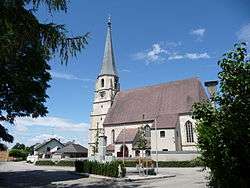 Church of Saint Andrew | |
 Coat of arms | |
 Polling im Innkreis Location within Austria | |
| Coordinates: 48°13′50″N 13°16′50″E | |
| Country | Austria |
| State | Upper Austria |
| District | Braunau am Inn |
| Government | |
| • Mayor | Karl Reiter-Stranzinger (ÖVP) |
| Area | |
| • Total | 15.11 km2 (5.83 sq mi) |
| Elevation | 385 m (1,263 ft) |
| Population (2018-01-01)[2] | |
| • Total | 997 |
| • Density | 66/km2 (170/sq mi) |
| Time zone | UTC+1 (CET) |
| • Summer (DST) | UTC+2 (CEST) |
| Postal code | 4951 |
| Area code | 07723 |
| Vehicle registration | BR |
| Website | http://www.polling-innkreis.ooe.gv.at/ |
Geography
Polling lies in the Innviertel. About 10 percent of the municipality is forest and 86 percent farmland.
gollark: Yes, because it's part of a true document.
gollark: Sadly, I ran out of GPT-3 trial credits.
gollark: This is substantially worse grammar/spelling than usual.
gollark: Blehmished.
gollark: Apologize immediately.
References
- "Dauersiedlungsraum der Gemeinden Politischen Bezirke und Bundesländer - Gebietsstand 1.1.2018". Statistics Austria. Retrieved 10 March 2019.
- "Einwohnerzahl 1.1.2018 nach Gemeinden mit Status, Gebietsstand 1.1.2018". Statistics Austria. Retrieved 9 March 2019.
| Wikimedia Commons has media related to Polling im Innkreis. |
This article is issued from Wikipedia. The text is licensed under Creative Commons - Attribution - Sharealike. Additional terms may apply for the media files.