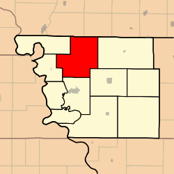
Polk Township, Atchison County, Missouri
Polk Township is one of eleven townships in Atchison County, Missouri, United States. As of the 2010 census, its population was 226.[3]
Polk Township | |
|---|---|
 | |
| Coordinates: 40°31′16″N 095°30′38″W | |
| Country | |
| State | |
| County | Atchison |
| Area | |
| • Total | 161.41 km2 (62.32 sq mi) |
| • Land | 161.41 km2 (62.32 sq mi) |
| • Water | 0 km2 (0 sq mi) 0% |
| Elevation | 303 m (994 ft) |
| Population (2010) | |
| • Total | 226 |
| • Density | 1.4/km2 (4/sq mi) |
| FIPS code | 29-58700[2] |
| GNIS feature ID | 0766238 |
Polk Township was established in 1845, and named after President James K. Polk.[4]
Geography
Polk Township covers an area of and contains no incorporated settlements. It contains six cemeteries: High Creek, Linden, St. John's Lutheran, Grange Hall, Noblitt-gibson, and Steiner.
The streams of McElroy Creek, High Creek, West High Creek, and Hall Branch run through this township.
gollark: There's context of some sort.
gollark: Hold on while I reread the page so I can reload it into my braincache™.
gollark: But palaiologos CLAIMS to be objective a lot.
gollark: See, this is point 3 - you're bad at subjectivity.
gollark: I **sort of** agree but don't like how it's expressed.
References
- "US Board on Geographic Names". United States Geological Survey. 2007-10-25. Retrieved 2008-01-31.
- "U.S. Census website". United States Census Bureau. Retrieved 2008-01-31.
- "Geographic Identifiers: 2010 Demographic Profile Data (G001): Polk township, Atchison County, Missouri". U.S. Census Bureau, American Factfinder. Archived from the original on February 12, 2020. Retrieved June 25, 2013.
- "Atchison County Place Names, 1928-1945 (archived)". The State Historical Society of Missouri. Archived from the original on 24 June 2016. Retrieved 30 August 2016.CS1 maint: BOT: original-url status unknown (link)
External links
Municipalities and communities of Atchison County, Missouri, United States | ||
|---|---|---|
| Cities | 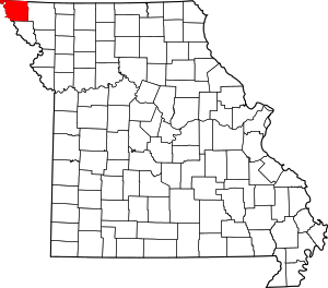 Map of Missouri highlighting Atchison County | |
| Village | ||
| Townships | ||
| CDPs | ||
| Unincorporated communities | ||
| Ghost towns | ||
This article is issued from Wikipedia. The text is licensed under Creative Commons - Attribution - Sharealike. Additional terms may apply for the media files.