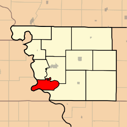
Benton Township, Atchison County, Missouri
Benton Township is one of eleven townships in Atchison County, Missouri, United States. As of the 2010 census, its population was 23.[3]
Benton Township | |
|---|---|
 | |
| Coordinates: 40°19′21″N 095°32′58″W | |
| Country | |
| State | |
| County | Atchison |
| Area | |
| • Total | 51.34 km2 (19.82 sq mi) |
| • Land | 49.94 km2 (19.28 sq mi) |
| • Water | 1.40 km2 (0.54 sq mi) 2.73% |
| Elevation | 268 m (879 ft) |
| Population (2010) | |
| • Total | 23 |
| • Density | 0.5/km2 (1/sq mi) |
| FIPS code | 29-04582[2] |
| GNIS feature ID | 0766230 |
Benton Township was established in 1858, and named after Thomas Hart Benton, a Missouri senator.[4]
Geography
Benton Township covers an area of 19.8 square miles (51.3 km2) and contains no incorporated settlements.
The stream of State Line Slough runs through this township.
gollark: Without this, bees are not a renewable resource and we may face a "peak bee" crisis.
gollark: @all staff ever Please fix markets being unable to sell queen bees.
gollark: Why would it be that? That's longer and thus impossible by Occam's razor.
gollark: You're clearly bad and unaware of how potatOS was potatOSed.
gollark: Just disable them?
References
- "US Board on Geographic Names". United States Geological Survey. 2007-10-25. Retrieved 2008-01-31.
- "U.S. Census website". United States Census Bureau. Retrieved 2008-01-31.
- "Geographic Identifiers: 2010 Demographic Profile Data (G001): Benton township, Atchison County, Missouri". U.S. Census Bureau, American Factfinder. Archived from the original on February 12, 2020. Retrieved June 21, 2013.
- "Atchison County Place Names, 1928-1945 (archived)". The State Historical Society of Missouri. Archived from the original on 24 June 2016. Retrieved 30 August 2016.CS1 maint: BOT: original-url status unknown (link)
External links
Municipalities and communities of Atchison County, Missouri, United States | ||
|---|---|---|
| Cities | 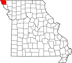 Map of Missouri highlighting Atchison County | |
| Village | ||
| Townships | ||
| CDPs | ||
| Unincorporated communities | ||
| Ghost towns | ||
This article is issued from Wikipedia. The text is licensed under Creative Commons - Attribution - Sharealike. Additional terms may apply for the media files.