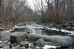
Pohick Creek
Pohick Creek is a 14.0-mile-long (22.5 km)[5] tributary stream of the Potomac River in Fairfax County in the U.S. state of Virginia. It takes its name from the Pohick Native American tribe once prevalent in the area.
| Pohick Creek Tributary to Potomac River | |
|---|---|
 | |
 Location of Pohick Creek mouth  Pohick Creek (the United States) | |
| Location | |
| Country | United States |
| State | Virginia |
| County | Fairfax |
| Physical characteristics | |
| Source | confluence of Rabbit Branch and Sideburn Branch |
| • location | Fairfax, Virginia |
| • coordinates | 38°47′52″N 077°17′04″W[1] |
| • elevation | 262 ft (80 m)[2] |
| Mouth | Potomac River (Pohick Bay) |
• location | about 0.5 miles north of Springfield Farms, Virginia |
• coordinates | 38°41′07″N 077°11′12″W[1] |
• elevation | 0 ft (0 m)[2] |
| Length | 14.32 mi (23.05 km)[3] |
| Basin size | 32.21 square miles (83.4 km2)[4] |
| Discharge | |
| • location | Potomac River (Pohick Bay) |
| • average | 41.20 cu ft/s (1.167 m3/s) at mouth with Potomac River[4] |
| Basin features | |
| Progression | southeast |
| River system | Potomac River |
| Tributaries | |
| • left | Rabbit Branch |
| • right | Sideburn Branch Middle Run South Run Rocky Branch |
| Waterbodies | Lake Royal |
| Bridges | Commonwealth Boulevard, Guinea Road, Burke Lake Road, Old Keene Mill Road, VA 286, Pohick Road, I-95, Lorton Road, US 1, Old Colchester Road |
Pohick Creek forms in the vicinity of Burke and flows southeast past the western edge of Fort Belvoir to empty into the tidal Pohick Bay, which itself empties, along with Accotink Bay, into Gunston Cove, an embayment of the tidal Potomac River. Pohick Creek is a popular stream for whitewater kayaking, rafting, and paddling, providing Class II and III rapids along a 5.5-mile (8.9 km) stretch between Hooes Road (Virginia Secondary Route 636) and the Richmond Highway (U.S. Route 1) at Lorton.
Several tributaries of the Pohick Creek are impounded by dams constructed under the Watershed Protection and Flood Prevention Act to prevent soil erosion and flooding. Originally eight dams were planned, but from 1970 to 1985, only six were actually built.
- Lake Braddock (Pohick #7) was the first dam built in 1970, and impounds the Pohick Creek in Burke.
- Huntsman Lake (Pohick #8) was built in 1973, and impounds the Middle Run in Springfield.
- Lake Royal (Pohick #4) was completed in 1977, and impounds the Rabbit Branch in Burke above its confluence with the Sideburn Branch, where it forms Pohick Creek.
- Lake Barton (Pohick #2) completed in 1978, impounds a tributary of the Sideburn Branch in Burke.
- Woodglen Lake (Pohick #3), which impounds the Sideburn Branch in Fairfax, was completed in 1981.
- Lake Mercer (Pohick #1) became in 1985 the final dam completed, impounding the South Run in Springfield.
Variant names
The following variant names have been listed on the Geographic Names Information System by the United States Geological Survey.
- North West Branch
- Poehick Creeke
- Poheick Creek
- West Branch
Course
Pohick Creek forms at the confluence of Rabbit Branch and Sideburn Branch in Fairfax, Virginia. Pohick Creek Creek then flows southeast through Pohick Valley Stream Park to meet the Potomac River in Pohick Bay about 0.5 miles north of Springfield Farms, Virginia.[2]
Watershed
Pohick Creek drains 32.21 square miles (83.4 km2) of area, receives about 43.5 in/year of precipitation, has a topographic wetness index of 409.88 and is about 31.0% forested.[4]
See also
- Accotink Bay Wildlife Refuge
- List of rivers of Virginia
- Pohick Church
- Pohick, Virginia
- SM-1 closed nuclear power plant on Fort Belvoir
- MH-1A floating nuclear power plant
Maps
.gif)
.gif)
References
- "GNIS Detail - Pohick Creek". geonames.usgs.gov. US Geological Survey. Retrieved 11 March 2020.
- "Pohick Creek Topo Map, Fairfax County VA (Fort Belvoir Area)". TopoZone. Locality, LLC. Retrieved 11 March 2020.
- "ArcGIS Web Application". epa.maps.arcgis.com. US EPA. Retrieved 11 March 2020.
- "Watershed Report | Office of Water | US EPA". watersgeo.epa.gov. Retrieved 11 March 2020.
- U.S. Geological Survey. National Hydrography Dataset high-resolution flowline data. The National Map, accessed August 15, 2011