Pochalla Airport
Pochalla Airport is an airport serving Pochalla in South Sudan.
Pochalla Airport | |||||||||||
|---|---|---|---|---|---|---|---|---|---|---|---|
| Summary | |||||||||||
| Airport type | Public, Civilian | ||||||||||
| Owner | Civil Aviation Authority of South Sudan | ||||||||||
| Serves | Pochalla, South Sudan | ||||||||||
| Location | Pochalla, | ||||||||||
| Elevation AMSL | 2,000 ft / 600 m | ||||||||||
| Coordinates | 07°10′48″N 34°05′42″E | ||||||||||
| Map | |||||||||||
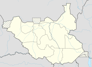 Pochalla Location of Pochalla Airport in South Sudan | |||||||||||
| Runways | |||||||||||
| |||||||||||
Location
Pochalla Airport (IATA: n/a, ICAO: HSPA) is located in Pochalla County in Boma State, in the town of Pochalla, in eastern South Sudan, at the international border with Ethiopia.
This location lies approximately 375 kilometres (233 mi), by air, east of Juba International Airport, the largest airport in South Sudan.[1] The geographic coordinates of Pochalla Airport are: 7° 10' 48.00" N, 34° 5' 42.00"E (Latitude: 7.1800; Longitude: 34.0950). Pochalla Airport is situated 600 metres (2,000 ft) above sea level.[2] The airport has a single unpaved runway.
Overview
Pochalla Airport is a small civilian airport that serves the town of Pochalla and Boma National Park. There are no scheduled flights at Pochalla Airport at this time.
External links
References
- "Distance between Pochala and Sudan". distancecalculator.globefeed.com. Retrieved 2018-08-24.
- Estimated Elevation of Pachella Airport
State capital: Bor | ||
| Populated places | 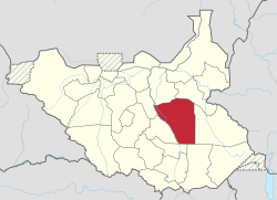 | |
| Universities | ||
| Airports | ||
| Other |
| |