Pho Thale District
Pho Thale (Thai: โพทะเล, pronounced [pʰōː tʰā.lēː]) is a district (amphoe) in the southwestern part of Phichit Province, central Thailand.
Pho Thale โพทะเล | |
|---|---|
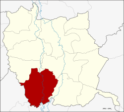 Amphoe location in Phichit Province | |
| Coordinates: 16°4′30″N 100°18′12″E | |
| Country | Thailand |
| Province | Phichit |
| Seat | Tha Bua |
| Area | |
| • Total | 484.4 km2 (187.0 sq mi) |
| Population (2009) | |
| • Total | 60,781 |
| • Density | 127.1/km2 (329/sq mi) |
| Time zone | UTC+7 (ICT) |
| Postal code | 66130 |
| Geocode | 6606 |
Geography
Neighboring districts are (from the northwest clockwise) Bueng Na Rang, Taphan Hin, Bang Mun Nak of Phichit Province, Chum Saeng, Kao Liao and Banphot Phisai of Nakhon Sawan Province.
History
In 1939, the district office was moved from Bang Khlan Sub-district to Ban Tan Sub-district.[1] Later the same year, the district was renamed from Bang Khlan to Pho Thale, and the sub-district Ban Tan also to Pho Thale.[2]
Administration
The district is divided into 11 sub-districts (tambon), which are further subdivided into 98 villages (muban). There are two sub-district municipalities (thesaban tambon) - Pho Thale covers parts of tambon Pho Thale, and Tha Sao parts of tambon Tha Sao and Tha Khamin. There are a further 11 tambon administrative organizations (TAO).
| No. | Name | Thai | Villages | Pop.[3] |
|---|---|---|---|---|
| 1. | Pho Thale | โพทะเล | 9 | 7,558 |
| 2. | Thai Nam | ท้ายน้ำ | 11 | 5,786 |
| 3. | Thanong | ทะนง | 11 | 7,863 |
| 4. | Tha Bua | ท่าบัว | 13 | 7,033 |
| 5. | Thung Noi | ทุ่งน้อย | 7 | 3,722 |
| 6. | Tha Khamin | ท่าขมิ้น | 12 | 5,607 |
| 7. | Tha Sao | ท่าเสา | 9 | 6,052 |
| 8. | Bang Khlan | บางคลาน | 6 | 3,918 |
| 11. | Tha Nang | ท่านั่ง | 6 | 3,889 |
| 12. | Ban Noi | บ้านน้อย | 6 | 3,876 |
| 13. | Wat Khwang | วัดขวาง | 8 | 5,477 |
Missing numbers are tambon which now form Bueng Narang district.
References
- ประกาศกระทรวงมหาดไทย เรื่อง ย้ายที่ว่าการอำเภอบางคลาน จังหวัดพิจิตร (PDF). Royal Gazette (in Thai). 55 (ง): 3400. 1939-01-16.
- พระราชกฤษฎีกาเปลี่ยนนามอำเภอ กิ่งอำเภอ และตำบลบางแห่ง พุทธศักราช ๒๔๘๒ (PDF). Royal Gazette (in Thai). 56 (ก): 354–364. April 17, 1939.
- "Population statistics 2009". Department of Provincial Administration. Archived from the original on 2016-03-04.