Payrin-Augmontel
Payrin-Augmontel is a commune in the Tarn department in southern France.
Payrin-Augmontel | |
|---|---|
.svg.png) Coat of arms | |
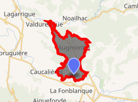
Location of Payrin-Augmontel 
| |
 Payrin-Augmontel  Payrin-Augmontel | |
| Coordinates: 43°31′08″N 2°20′56″E | |
| Country | France |
| Region | Occitanie |
| Department | Tarn |
| Arrondissement | Castres |
| Canton | Mazamet-1 |
| Government | |
| • Mayor (2001–2008) | Jean-Louis Henry |
| Area 1 | 12.84 km2 (4.96 sq mi) |
| Population (2017-01-01)[1] | 2,168 |
| • Density | 170/km2 (440/sq mi) |
| Time zone | UTC+01:00 (CET) |
| • Summer (DST) | UTC+02:00 (CEST) |
| INSEE/Postal code | 81204 /81660 |
| Elevation | 185–370 m (607–1,214 ft) (avg. 225 m or 738 ft) |
| 1 French Land Register data, which excludes lakes, ponds, glaciers > 1 km2 (0.386 sq mi or 247 acres) and river estuaries. | |
Geography
The Espinat forms most of the commune's eastern border, then flows into the Thoré, which forms the commune's southern border.
gollark: > massive number of people... *how* massive?
gollark: > yeah because they know the nhs is shitDid you just say BAD THINGS about the GLORIOUS NHS?!?!?!?!?!?!?!!?!?!?!??!?! You must want to PRIVATIZE IT!!!!!! Initiating orbital laser strike.
gollark: Except Epicbot is JS.
gollark: Python has `random.choices` or something now.
gollark: Your brain should be better at not dying.
See also
References
- "Populations légales 2017". INSEE. Retrieved 6 January 2020.
| Wikimedia Commons has media related to Payrin-Augmontel. |
This article is issued from Wikipedia. The text is licensed under Creative Commons - Attribution - Sharealike. Additional terms may apply for the media files.