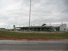
Palmas Airport
Palmas–Brigadeiro Lysias Rodrigues Airport (IATA: PMW, ICAO: SBPJ) is the airport serving Palmas, Brazil. The airport is named after Brigadier Lysias Augusto Rodrigues (1896-1957), one of the founding figures of the Brazilian Air Force and crucial to the integration of Tocantins to Brazil via the passenger air services of the Brazilian Air Force.[4]
Palmas–Brigadeiro Lysias Rodrigues Airport Aeroporto de Palmas–Brigadeiro Lysias Rodrigues | |||||||||||
|---|---|---|---|---|---|---|---|---|---|---|---|
 | |||||||||||
| Summary | |||||||||||
| Airport type | Public | ||||||||||
| Operator | Infraero | ||||||||||
| Serves | Palmas | ||||||||||
| Elevation AMSL | 236 m / 774 ft | ||||||||||
| Coordinates | 10°17′24″S 048°21′28″W | ||||||||||
| Website | www4 | ||||||||||
| Map | |||||||||||
 PMW Location in Brazil | |||||||||||
| Runways | |||||||||||
| |||||||||||
| Statistics (2019) | |||||||||||
| |||||||||||
It is operated by Infraero.
History
The airport was commissioned on October 5, 2001. It has an area of 23,739,952.00m² which is enough to future expansions. The terminal has 12,300m² and a capacity for 2 100,000 passengers/year.
Airlines and destinations
| Airlines | Destinations |
|---|---|
| Azul Brazilian Airlines | Campinas, Goiânia |
| Gol Transportes Aéreos | Brasília |
| LATAM Brasil | São Paulo–Guarulhos |
Access
The airport is located 20 km (12 mi) from downtown Palmas.
gollark: How mysterious.
gollark: > haha idiot lion cannot sharpen stick has no opposable thumb will go extinctyes.
gollark: Hmm. Maybe I should buy one of these shiny 256GB µSD card things.
gollark: How should I know, I've never eaten or interacted with an onion before.
gollark: Sorry, broken extension and discord bad.
See also
References
- "Estatísticas". Infraero (in Portuguese). 20 February 2020. Retrieved 5 June 2020.
- "Aeroporto Brigadeiro Lysias Rodrigues". Infraero (in Portuguese). Retrieved 5 June 2020.
- "Aeródromos". ANAC (in Portuguese). 15 October 2019. Retrieved 5 June 2020.
- Cambeses Júnior, Manuel. "Major-Brigadeiro-do-Ar Lysias Augusto Rodrigues" (PDF). Incaer (in Portuguese). Archived from the original (PDF) on 2 December 2012. Retrieved 19 May 2011.
External links
- Airport information for SBPJ at World Aero Data. Data current as of October 2006.Source: DAFIF.
- Airport information for SBPJ at Great Circle Mapper. Source: DAFIF (effective October 2006).
- Current weather for SBPJ at NOAA/NWS
- Accident history for PMW at Aviation Safety Network
This article is issued from Wikipedia. The text is licensed under Creative Commons - Attribution - Sharealike. Additional terms may apply for the media files.