Pallippuram, Palakkad
Pallippuram (![]()
Pallippuram | |
|---|---|
Village | |
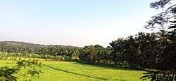 Pallippuram paddy fields | |
 Pallippuram Location in Kerala, India  Pallippuram Pallippuram (India) | |
| Coordinates: 10.84057°N 76.11183°E | |
| Country | |
| State | Kerala |
| District | Palakkad |
| Area | |
| • Total | 20.71 km2 (8.00 sq mi) |
| Elevation | 14.83 m (48.65 ft) |
| Population (2001) | |
| • Total | 21,809 |
| • Density | 1,053/km2 (2,730/sq mi) |
| Languages | |
| • Official | Malayalam, English |
| Time zone | UTC+5:30 (IST) |
| PIN | 679 305 |
| Telephone code | 91466 |
| Vehicle registration | KL-52 |
Demography
This village has a population of 21,000 people, where 10,000 are males and 11,000 females as of 2001 India census,.[1] The population density is high at 1,053 persons per km². Muslims comprise approximately 65 per cent of the population, and Hindus the rest. According to the census, the birth rate is 246 and death rate is 5.9 per annum. 88.65% of the population is literate (males: 90.24; females: 83.38).
References
- "Census of India 2001: Data from the 2001 Census, including cities, villages and towns (Provisional)". Census Commission of India. Archived from the original on 16 June 2004. Retrieved 1 November 2008.
External links
| Wikimedia Commons has media related to Pallippuram, Palakkad. |