Kunnamkulam
Kunnamkulam is a municipal town situated in the Thrissur District of Kerala in India, spread over an area of 34.18 km2. It is an old commercial town, with an ancient history, famous for its printing and book binding industry. It is the chief centre of the Malankara Orthodox Syrian Christians in the Kerala state. In the past, the town was called Kunnankulangara and references can be seen many British Archives about a neat and prosperous town which was predominantly Christian. Over the years Kunnamkulam has become a meeting point for all religions.[1]
Kunnamkulam | |
|---|---|
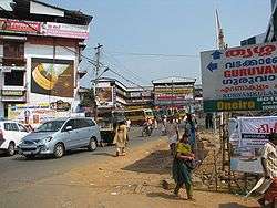
 Kunnamkulam bus stand | |
| Coordinates: 10.65°N 76.08°E | |
| Country | |
| State | Kerala |
| District | Thrissur District |
| Area | |
| • Total | 34.18 km2 (13.20 sq mi) |
| Elevation | 57 m (187 ft) |
| Population (2001) | |
| • Total | 54,071 |
| • Density | 1,600/km2 (4,100/sq mi) |
| Languages | |
| • Official | Malayalam, English |
| Time zone | UTC+5:30 (IST) |
| PIN | |
History
The history of Kunnamkulam turns back to the Paleolithic age. Kakkad cave and Chowannur cave support this fact. It is said that this place was part of 'Mahodaya Pattanam' and was known as 'Kunnamkulangare'.[1][2]
Traditionally it is believed that a cross was installed by Thomas the Apostle, at Chattukulangara (a part of Arthat in Kunnamkulam). During the invasion of Tippu Sultan in 1789, the Christians from Chattakulangara migrated to Kunnamkulam town after the invitation from Thalapilli Rajas. The Thalapilli Rajas provided residences and places of workship.[3][1]
Most of the oldest and wealthiest Christian families are to be found in Kunnamkulam. Kollannoor, Panakkal, Paramel, Pulikottil, Thengungal, Cheeran, Moolapath, Tholath and Kakkassery were prominent among them. The ascendancy competition between these wealthy families, its contexture to literary activities opened new dimensions in the development of printing. Panakkal Chakku, Cheru, Thengungal Ittoop, Varu and Koothur Paramel Iyyu Uttoop were arbitrators of some of these families. It is said that the Christian families were settled earlier at Chattukulangare shifted to Kunnamkulam after the invasion of Tippu in 1789. They were invited by the Thalappilli Rajas, provided residences and places of worship. They resided on both sides of the street. This may have helped to avoid threat from Tippu against Thalappilli Rajas. Those settled on both sides of the street started trade and business, began a new era of transaction. [1]
Kunnamkulam Municipal area was the headquarters of Talappilly taluk up to AD1860.
Geography
Kunnamkulam is located at 10.65°N 76.08°E.[4] It has an average elevation of 57 metres (187 feet). It is around 23 km from Thrissur City and 10 km from Guruvayur. It is located on the route connecting Thrissur, Kochi to North Kerala.
Kunnamkulam, as the word connotes is the land of hills and ponds. The hills, 'Adupputty', 'Kizhoor' and 'Kakkad' lies in the borders and the ponds 'Enjhankulam', 'Ayyamkulam', and 'Madhurakulam' are in the middle. Manakulam, Cheralayam and Kakkad, the suburbs of Kunnamkulam were the seats of the Nambidis of Manakulam, Ayinikur and Kakkad Karanavappad respectively. They were collectively known as Thalappilli Rajas and belonged to three branches of the same dynasty.[1]
Government
The Kunnamkulam Municipality was formed as an IVth grade Municipality in the year 1948. The Municipality had an area of 6.96 km2 and is divided into 31 electoral wards. In 2000, it was further upgraded to a Grade-II Municipality by merging adjoining panchayats of Arthat (full) and panchayats of Porkulam and Chowwannur (parts). The original area of the municipality was 7 km2 which is now increased to 34.18 km2. Earlier, there were only 16 municipal wards. The municipality extended its area in 2001 and now has 31 wards. The Total population then was 51,585 of which 24,396 were males and 27,189 females, with the density of population being 2,824 per km2.[5] Kunnamkulam assembly constituency is part of Alathoor (Lok Sabha Constituency). Earlier, it was part of the Ottapalam Constituency.[6]
Culture

Kadavallur, Chowannur and Arthat, the nearby places of Kunnamkulam had a rich cultural background. Kadavallur is well known throughout this coast as being the place where Nambudiris of the Thrissur and Tirunavaya Yogams compete for superiority in Vedic proficiency. In Chowannur, there was a Sabha Madom, an endowed college where Sanskrit education was given. Arthat was the chief center of Orthodox Christians. The Arthat St. Mary's Cathedral Church(Arthat Valliyapally) is the main church in the town. All these contributed a cultural rising up in the area which later on helped the development of the publishing industry. These published books were sold during Guruvayur Ekadasi. When the temple was open to all Hindus and a good amount of trade taken place at that time.[7]
Line Houses
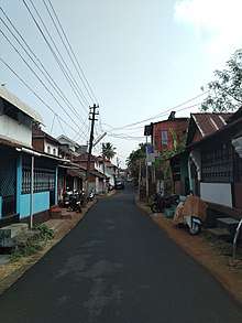
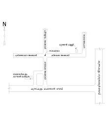
A particular residential replica "line houses" (angadi pura (veeducal)), is seen in Kunnamkulam area. The streets of these houses are exceedingly narrow. The "Line Houses" are built in 3–5 cents of land on both sides of the street. The front room of the house functions as a shop while the rear room was used for residential purposes. There used to be rear yards for every so called "Angadi pura" (town house) which was used for processing of their agricultural products.[3][7][8]
Kunnamkulam is famous for its religious harmony as Hindus, Christians and Muslims live here. The religious tolerance of Kunnamkulam people can be seen from the “Ambala Palli’(located at south Bazar) which is temple converted to a church where in, the temple character can be seen in the church entrance.

Archaeology
- Roman coins of Eyyal: Archaeologists have unearthed a collection of old Roman coins at Eyyal. These coins date from 123 AC to 117 AD. They are currently exhibited in the Archeological Museum of Thrissur.[9]
See also
References
- "THE PROBLEMS AND PROSPECTS OF PAPER-BASED INDUSTRY IN KUNNAMKULAM(A Local Level Study)" (PDF). CENTRE FOR DEVELOPMENT STUDIES. 1 January 2000. Archived (PDF) from the original on 29 March 2017. Retrieved 7 January 2020.
- "Monuments | Archelogical survey of India :: Thrissur Circle". www.asithrissurcircle.in. Retrieved 7 January 2020.
- "National Urban Observatory". Town & country planning organization. Retrieved 4 December 2010.
- Falling Rain Genomics, Inc - Kunnamkulam
- "Profile". Janasevana Kendram. Retrieved 7 December 2010.
- Ottapalam Constituency website
- "The problems and prospects of paper-based industry in Kunnamkulam". Rajeev G. Retrieved 4 December 2010.
- "Kunnamkulam PinCode". citypincode.in. Retrieved 19 May 2014.
- "Keralathile Sthalanama Charithram" of Sri. V. V. Valath, and "Makothai Pattanam" written by Sri V. T. Induchoodan, in the Mathrubhumi Annual, 1970.
| Wikimedia Commons has media related to Kunnamkulam. |