Mannarkkad
Mannarkkad, formerly known as Mannarghat, is a municipal City in Palakkad district of the Indian state of Kerala.
Mannarkkad Mannarghat | |
|---|---|
City | |
 Mannarkkad Location in Kerala, India  Mannarkkad Mannarkkad (India) | |
| Coordinates: 10.98°N 76.47°E | |
| Country | |
| State | Kerala |
| District | Palakkad District |
| Government | |
| • Type | Municipality |
| • Body | Municipality |
| Area | |
| • Total | 32 km2 (12 sq mi) |
| Area rank | 24 |
| Elevation | 76 m (249 ft) |
| Demonym(s) | Mannarkkadans |
| Languages | |
| • Official | Malayalam |
| Time zone | UTC+5:30 (IST) |
| Telephone code | + 91 ,STD (04924) |
| Vehicle registration | KL-50 |
Geography
Mannarkkad is located at 10.98°N 76.47°E.[1] It has an average elevation of 76 m (249 ft). It is situated 40 km north-west of the district headquarters Palakkad, on the way to Kozhikode, which is 100 km north-west. Mannarkkad is located in the foothills of the Western Ghats.
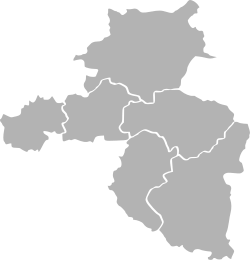
Mannarkkad Taluk
Mannarkkad is one of the six Taluks of Palakkad district.
gollark: Clearly you looked wrong.
gollark: I don't know if you noticed.
gollark: He *is* still here.
gollark: not really. can you explain more then?
gollark: But I think I would at least want to ask whoever found an exploit if I managed to fix it or if it's still there.
References
External links
| Wikimedia Commons has media related to Mannarkkad. |

| Taluks of Palakkad District, Kerala |
|---|
| Alathur • Chittur • Mannarkkad • Ottapalam • Pattambi • Palakkad |
This article is issued from Wikipedia. The text is licensed under Creative Commons - Attribution - Sharealike. Additional terms may apply for the media files.
