Pabellón de Arteaga Municipality
Pabellón de Arteaga is municipality in the Mexican state of Aguascalientes. It stands at 22°09′N 102°16′W in the central part of the state. The city of Pabellón de Arteaga (2010 population: 28,633) serves as its municipal seat. The municipality had a population of 41,862 and an area of 199.33 km² (76.97 sq mi). Its largest other town is named Emiliano Zapata.
Pabellón de Arteaga | |
|---|---|
Municipality | |
 Coat of arms | |
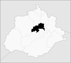 Municipality location in Aguascalientes | |
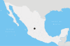
Pabellón de Arteaga Location in Mexico | |
| Coordinates: 22°09′N 102°16′W | |
| Country | |
| State | Aguascalientes |
| Municipal seat | Pabellón de Arteaga |
| Area | |
| • Total | 199.72 km2 (77.11 sq mi) |
| Population (2015) | |
| • Total | 46,473 |
| • Density | 230/km2 (600/sq mi) |
Demographics
As of 2010, the municipality had a total population of 41,862.[1]
As of 2010, the city of Pabellón de Arteaga had a population of 28,633.[1] Other than the city of Pabellón de Arteaga, the municipality had 300 localities, the largest of which (with 2010 populations in parentheses) were: Emiliano Zapata (2,995), classified as urban, and Las Ánimas (1,794), Santa Isabel (1,065), Santiago (1,020), and San Luis de Letras (1,018), classified as rural.[1]
References
- "Pabellón de Arteaga". Catálogo de Localidades. Secretaría de Desarrollo Social (SEDESOL). Retrieved 23 April 2014.
- Link to tables of population data from Census of 2005 Instituto Nacional de Estadística, Geografía e Informática (INEGI)
- Aguascalientes Enciclopedia de los Municipios de México
External links
- Ayuntamiento de Pabellón de Arteaga Official website
- Aguascalientes state government (in Spanish)
Aguascalientes City (capital) | ||
| Municipalities and (municipal seats) |
|  |
| ||