Jesús María Municipality
Jesús María is a municipality in the Mexican state of Aguascalientes. It stands at 21°58′N 102°21′W. As of 2010, the municipality had a total population of 99,590.[1]
Jesús María | |
|---|---|
Municipality | |
 Coat of arms | |
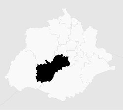 Municipality location in Aguascalientes | |
| Coordinates: 21°58′N 102°21′W | |
| Country | |
| State | |
| Founded | 29 October 1833 |
| Seat | Jesús María |
| Largest city | Jesús María |
| Area | |
| • Total | 506.32 km2 (195.49 sq mi) |
| Population (2015) | |
| • Total | 120,405 |
| • Density | 240/km2 (620/sq mi) |
History
Geography
The municipality has an area of 499.18 km² (192.73 sq mi).
Major highways
Adjacent municipalities
- San José de Garcia Municipality (north)
- Pabellón de Arteaga Municipality (north)
- San Francisco de los Romo Municipality (east)
- Aguascalientes Municipality (southeast)
- Calvillo Municipality (west)
Demographics
As of 2010, the city of Jesús María, the municipal seat, had a population of 43,012.[1] Other than the city of Jesús María, the municipality had 346 localities, the largest of which (with 2010 populations in parentheses) were: Jesús Gómez Portugal (Margaritas) (11,589), Paseos de Aguascalientes (4,432), Arboledas Paso Blanco (3,313), Corral de Barrancos (3,158), El Llano (2,571), classified as urban, and Maravillas (2,208), Paso Blanco (1,709), Tepetates (1,683), General Ignacio Zaragoza (Venadero) (1,630), Paseos de las Haciendas (1,596), Valladolid (1,411), San Antonio de los Horcones (1,254), Los Arquitos (1,120), Miravalle (1,071), and Ejido la Guayana (Rancho Seco) (1,028), classified as rural.[1]
References
- "Jesús María". Catálogo de Localidades. Secretaría de Desarrollo Social (SEDESOL). Retrieved 23 April 2014.
- Link to tables of population data from Census of 2005 Instituto Nacional de Estadística, Geografía e Informática (INEGI)
- Aguascalientes Enciclopedia de los Municipios de México
External links
- Municipio de Jesús María Official website
- Gobierno del Estado de Aguascalientes Official website of state of Aguascalientes
Places adjacent to Jesús María Municipality | ||||||||||
|---|---|---|---|---|---|---|---|---|---|---|
| ||||||||||
Aguascalientes City (capital) | ||
| Municipalities and (municipal seats) |
|  |
| ||