Outline of Nagaland
The following outline is provided as an overview of and topical guide to Nagaland:

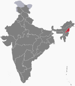
Location of Nagaland
Nagaland – state in Northeast India. It borders the state of Assam to the west, the state of Arunachal Pradesh and part of Assam to the north, Burma (now Myanmar) to the east and Manipur to the south. The state capital is Kohima, and the largest city is Dimapur. It has an area of 16,579 square kilometres (6,401 sq mi) with a population of 1,980,602 per the 2011 Census of India, making it one of the smallest states of India.[1]
General reference
Names
- Common English name: Nagaland
- Pronunciation: /ˈnɑːɡəlænd/
- Official English name(s): Nagaland
- Nickname(s):
- Adjectival(s):
- Naga
- Nagalandese
- Demonym(s): Nagas
Rankings (amongst India's states)
- by population: 25th
- by area (2011 census): 26th
- by crime rate (2015): 29th
- by gross domestic product (GDP) (2014): 25th
- by Human Development Index (HDI):
- by life expectancy at birth:
- by literacy rate:
Geography of Nagaland
Geography of Nagaland
- Nagaland is: an Indian state, and one of the Seven Sister States
- Population of Nagaland: 1,980,602 (2011)
- Area of Nagaland: 16,579 km2 (6,401 sq mi)
- Atlas of Nagaland
Location of Nagaland
- Nagaland is situated within the following regions:
- Northern Hemisphere
- Eastern Hemisphere
- Eurasia
- Asia
- South Asia
- India
- Northeastern India
- Seven Sister States
- Northeastern India
- India
- South Asia
- Asia
- Eurasia
- Time zone: Indian Standard Time (UTC+05:30)
Environment of Nagaland
Natural geographic features of Nagaland
- Highest point: Mount Saramati
Regions of Nagaland
Ecoregions of Nagaland
Administrative divisions of Nagaland
Districts of Nagaland
Demography of Nagaland
Demographics of Nagaland
Government and politics of Nagaland
- Form of government: Indian state government (parliamentary system of representative democracy)
- Capital of Nagaland: Kohima
- Elections in Nagaland
Union government in Nagaland
- Rajya Sabha members from Nagaland
- Nagaland Pradesh Congress Committee
- Indian general election, 2009 (Nagaland)
- Indian general election, 2014 (Nagaland)
Branches of the government of Nagaland
Executive branch of the government of Nagaland
- Head of state: Governor of Nagaland,
- Raj Bhavan – official residence of the Governor
- Head of government: Chief Minister of Nagaland,
Legislative branch of the government of Nagaland
Judicial branch of the government of Nagaland
Law and order in Nagaland
- Law enforcement in Nagaland
History of Nagaland
History of Nagaland
History of Nagaland, by period
Prehistoric Nagaland
Ancient Nagaland
Medieval Nagaland
Colonial Nagaland
Contemporary Nagaland
History of Nagaland, by region
History of Nagaland, by subject
Culture of Nagaland
Culture of Nagaland
- Architecture of Nagaland
- Cuisine of Nagaland
- Monuments in Nagaland
- Monuments of National Importance in Nagaland
- State Protected Monuments in Nagaland
- World Heritage Sites in Nagaland
Art in Nagaland
People of Nagaland
- Naga people
- People from Nagaland
Sports in Nagaland
Sports in Nagaland
- Cricket in Nagaland
- Football in Nagaland
Symbols of Nagaland
Symbols of Nagaland
- State animal:
- State bird:
- State flower:
- State seal: Seal of Nagaland
- State tree:
Economy and infrastructure of Nagaland
- Tourism in Nagaland
Health in Nagaland
Health in Nagaland
gollark: +>insult
gollark: ÆÆÆÆÆÆÆÆÆÆÆÆÆÆÆÆÆÆÆÆÆÆÆÆÆÆÆÆÆÆÆÆÆÆÆÆÆÆÆÆÆÆÆÆÆÆÆÆÆÆÆÆÆÆÆÆÆÆÆÆÆÆÆÆÆÆÆÆÆÆÆÆÆÆÆÆÆÆÆÆÆÆÆÆÆÆÆÆ
gollark: APIONET has #apionet, apioid.
gollark: APIONET isn't in #general.
gollark: Nope!
See also
References
- Census of India 2011 Govt of India
This article is issued from Wikipedia. The text is licensed under Creative Commons - Attribution - Sharealike. Additional terms may apply for the media files.