Osage Township, Bourbon County, Kansas
Osage Township is a township in Bourbon County, Kansas, USA. As of the 2000 census, its population was 394.
Osage Township | |
|---|---|
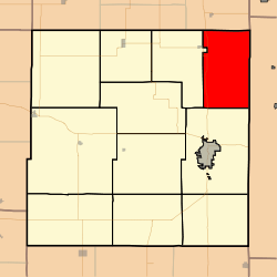 Location in Bourbon County | |
| Coordinates: 37°58′00″N 094°40′01″W | |
| Country | United States |
| State | Kansas |
| County | Bourbon |
| Area | |
| • Total | 48.39 sq mi (125.33 km2) |
| • Land | 48.31 sq mi (125.13 km2) |
| • Water | 0.08 sq mi (0.2 km2) 0.16% |
| Elevation | 853 ft (260 m) |
| Population (2000) | |
| • Total | 394 |
| • Density | 8.2/sq mi (3.1/km2) |
| GNIS feature ID | 0474559 |
Geography
Osage Township covers an area of 48.39 square miles (125.3 km2) and contains no incorporated settlements. According to the USGS, it contains four cemeteries: Barnesville, Fairview, Maple Grove and West Liberty.
The Little Osage River and smaller streams of Fish Creek, Indian Creek and Moores Branch run through this township. Fish Creek, Indian Creek and Moores Branch all enter the Little Osage in Osage Township.
Transportation
Osage Township contains two airports or landing strips: Emmerson Airport and Lyons Field.
Further reading
gollark: In fact, it practically *is* abuse.
gollark: Sickness: A Terrible Mechanic Which Allows Extensive Abuse.
gollark: Ah, yes, sickness, it makes so very much sense.
gollark: In my experience you need ~400 unique views.
gollark: Also try the forums' list of active fansites.
External links
- City-Data.com
- Bourbon County Maps: Current, Historic Collection
Municipalities and communities of Bourbon County, Kansas, United States | ||
|---|---|---|
| Cities | 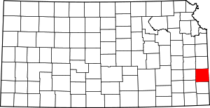 Map of Kansas highlighting Bourbon County | |
| Unincorporated communities | ||
| Townships | ||
This article is issued from Wikipedia. The text is licensed under Creative Commons - Attribution - Sharealike. Additional terms may apply for the media files.