Marmaton, Kansas
Marmaton is an unincorporated community in Bourbon County, United States.[1] The community is located three miles east of Redfield, and two miles south of U.S. Route 54, at the intersection of 155th Street and Limestone Road.
Marmaton, Kansas | |
|---|---|
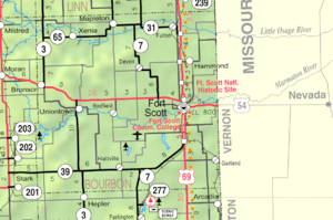 KDOT map of Bourbon County (legend) | |
| Coordinates: 37°49′55″N 94°49′29″W[1] | |
| Country | United States |
| State | Kansas |
| County | Bourbon |
| Township | Marmaton |
| Incorporated | 1858 |
| Elevation | 853 ft (260 m) |
| Time zone | UTC-6 (CST) |
| • Summer (DST) | UTC-5 (CDT) |
| Area code | 620 |
| FIPS code | 20-44875 [1] |
| GNIS ID | 474764 [1] |
History
Marmaton was incorporated in 1858. It was named for the Marmaton River, which crosses the township. Marmaton is a corruption of Marmiton, a French name given by fur traders meaning "scullion".[2]
The mailing address for residents of Marmaton is Fort Scott, Kansas.
Geography
The community is located three miles east of Redfield, and two miles south of U.S. Route 54, at the intersection of 155th Street and Limestone Road.
Further reading
gollark: <@341618941317349376> should stray from the light of Rust.
gollark: <@345300752975003649> <@190463009724825600>
gollark: <@345300752975003649> <@341618941317349376>
gollark: 🔥🦊: A Browser Which Isn't Chrome™
gollark: https://i.osmarks.tk/gVO9.jpg
References
- Geographic Names Information System (GNIS) details for Marmaton, Kansas; United States Geological Survey (USGS); October 13, 1978.
- Robley, T. F. (1894). History of Bourbon County, Kansas: To the Close of 1865. Press of the Monitor book & printing Company. pp. 98.
External links
Municipalities and communities of Bourbon County, Kansas, United States | ||
|---|---|---|
| Cities | 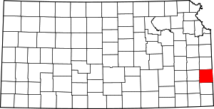 Map of Kansas highlighting Bourbon County | |
| Unincorporated communities | ||
| Townships | ||
This article is issued from Wikipedia. The text is licensed under Creative Commons - Attribution - Sharealike. Additional terms may apply for the media files.