Ortiporio
Ortiporio is a commune in the Haute-Corse department of France on the island of Corsica.
Ortiporio Ortiporiu | |
|---|---|
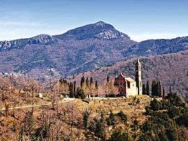 A view of the church of Saint-Augustin and the Monte Sant'Angelo | |
Location of Ortiporio 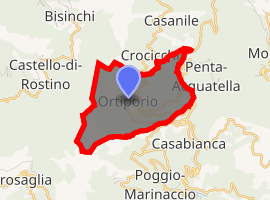
| |
 Ortiporio  Ortiporio | |
| Coordinates: 42°27′21″N 9°20′33″E | |
| Country | France |
| Region | Corsica |
| Department | Haute-Corse |
| Arrondissement | Corte |
| Canton | Golo-Morosaglia |
| Government | |
| • Mayor (2008–2014) | Sabrina Lunardi |
| Area 1 | 5 km2 (2 sq mi) |
| Population (2017-01-01)[1] | 127 |
| • Density | 25/km2 (66/sq mi) |
| Time zone | UTC+01:00 (CET) |
| • Summer (DST) | UTC+02:00 (CEST) |
| INSEE/Postal code | 2B195 /20290 |
| Elevation | 313–1,236 m (1,027–4,055 ft) (avg. 700 m or 2,300 ft) |
| 1 French Land Register data, which excludes lakes, ponds, glaciers > 1 km2 (0.386 sq mi or 247 acres) and river estuaries. | |
It is part of the canton of Golo-Morosaglia.[2]
Geography
Ortiporio is 24 kilometres (15 mi) to the south of Campitello at the foot of Mont Campuli, which is 1,236 metres (4,055 ft).
Population
| Year | Pop. | ±% |
|---|---|---|
| 1962 | 141 | — |
| 1968 | 167 | +18.4% |
| 1975 | 119 | −28.7% |
| 1982 | 100 | −16.0% |
| 1990 | 104 | +4.0% |
| 1999 | 113 | +8.7% |
| 2008 | 126 | +11.5% |
History
1934 - Night of 3 to 4 February : an avalanche caused the death of 37 persons. The snow level exceeded 1,50 m by place. A stele, in the church Saint-Augustine, reminds of this tragic disaster.[3]
gollark: Somewhat? There doesn't seem to be a better way to do it.
gollark: Hold on, I worked on a tiny bit of Go code, I'll dredge some up as a sample.
gollark: It does not avoid those. You just reimplement them oddly.
gollark: Explicit doesn't mean very good.
gollark: I would assume the issue isn't goroutines breaking the debugger as much as difficulty reasoning about concurrent programs in many cases.
References
- "Populations légales 2017". INSEE. Retrieved 6 January 2020.
- "Décret n° 2014-255 du 26 février 2014 portant délimitation des cantons dans le département de la Haute-Corse | Legifrance". Retrieved 2017-05-31.
- "Site officiel de la mairie d'Ortiporio". Archived from the original on 2009-09-10. Retrieved 2013-01-30.
| Wikimedia Commons has media related to Ortiporio. |
| Authority control |
|
|---|
This article is issued from Wikipedia. The text is licensed under Creative Commons - Attribution - Sharealike. Additional terms may apply for the media files.