Ohio State Route 32
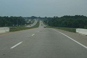
State Route 32, also known as SR 32 and the James A. Rhodes Appalachian Highway,[3] is a major east–west highway across the southern portion of the U.S. state of Ohio. It is the eighth longest state route in Ohio. It leads from eastern Cincinnati, near the border between the neighborhoods of Linwood, Mount Lookout, and Columbia-Tusculum, to the Parkersburg-Belpre Bridge across the Ohio River in Belpre. Except in Belpre, leading up to the bridge into West Virginia, the entire route outside Cincinnati's beltway (Interstate 275) is a high-speed four-lane divided highway, forming the Ohio portion of Corridor D of the Appalachian Development Highway System. This corridor continues east across the Ohio River over the Blennerhassett Island Bridge.
| |||||||
|---|---|---|---|---|---|---|---|
| James A. Rhodes Appalachian Highway | |||||||
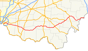 Route of SR 32 in southern Ohio highlighted in red | |||||||
| Route information | |||||||
| Maintained by ODOT | |||||||
| Length | 182.71 mi[1] (294.04 km) | ||||||
| Existed | 1962[2]–present | ||||||
| Major junctions | |||||||
| West end | |||||||
| |||||||
| East end | |||||||
| Highway system | |||||||
| |||||||


History
The Batavia Turnpike and Miami Bridge Company was incorporated and chartered by the state of Ohio. It built a road, which was "about finished" as of 1841, beginning at the Wooster Turnpike (Eastern Avenue), crossing the Little Miami River on the Union Bridge, and turning east to Batavia.[4][5] The Ohio Turnpike to Bethel split after the Little Miami was crossed.
The passage of the McGuire Bill in 1911 led to the designation of a large number of Inter-County Highways to be maintained by the Ohio Department of Highways.[6] This network included the Cincinnati-Batavia Road (ICH 41) and Batavia-Winchester Road (ICH 125), connecting Cincinnati to Batavia, Williamsburg, Mt. Orab, Sardinia, Winchester, and beyond to an intersection with the West Union-Belfast Road (ICH 122) south of Seaman (where Graces Run Road now meets State Route 247). This entire route from Cincinnati to south of Seaman was designated and signed as State Route 74 in 1923. The route left downtown Cincinnati on Eastern Avenue, shared with State Route 7 (now U.S. Route 52) and State Route 25 (now State Route 125). SR 7 left at Davis Lane (now Airport Road), while SR 25 and SR 74 turned onto Beechmont Avenue, splitting after crossing the Little Miami River. By 1925, the east end of SR 74 had been realigned and extended, heading east from Winchester through Seaman and continuing through Peebles to State Route 73 northwest of Rarden; the old alignment (Graces Run Road) reverted to local control. Along with U.S. Route 50, US 52, and SR 125, SR 74 was moved to Columbia Parkway in the early 1940s, and in the early 1950s it was removed from downtown Cincinnati to its present terminus. Due to the existence of Interstate 74 west of Cincinnati, the number was changed to State Route 32 in 1962, with SR 74 signs being removed in June 1963 after a period of dual signage. The designation had originally been applied to a route running from the Indiana border west of Celina to Marysville; in 1938 it was replaced by U.S. Route 33 east of St. Marys, and a rerouted State Route 54, later State Route 29, to the west.[2]
The state relocated the road between Mount Carmel and Batavia as a four-lane divided highway in the early 1960s, several years after the parallel State Route 125 was widened (but not realigned). Because this was done before or during the renumbering, the old road here is known as Old State Route 74, rather than Old State Route 32 to the east. Improvement of the rest of the road did not take place until after it was added to the Appalachian Development Highway System in 1965.[7] This proposed Appalachian Highway—part of Corridor D—was to run across the southern part of the state from Interstate 275 outside Cincinnati to Belpre.[8] From the east end of SR 32 east of Peebles, the route was to continue northeast, joining State Route 772 near Elmgrove, and following State Route 124 beyond Jackson to Roads. After continuing northeast to Radcliff, it would parallel State Route 346 and a portion of State Route 143, merging with U.S. Route 50 west of Albany and following it past Athens and Coolville to Belpre. A never-built branch, planned as part of Corridor B,[9] would have followed State Route 73 and State Route 348 from east of Peebles to Lucasville on U.S. Route 23 (Corridor C).[2]
In 1998, the Ohio Department of Transportation (ODOT) inspected a section of SR 32 in Jackson County due to repeated pavement failure and pothole subsidence featured in the median. Abandoned underground mines were visible near the roadway, but there were no mine maps available for the area. An electrical resistivity tomography was conducted to see if there were mine voids underneath the roadway. Several pits at 9.8 ft (3.0 m) deep were excavated revealing that mine voids were detected.[10] In response to the tests, ODOT closed the highway 1.5 mi (2.4 km) east of Wellston and began excavating the roadway to remediate the mine subsidence in November 1998.[11] Work to repair the roadway was completed in March 1999.[12]
In 2002, two interchanges were constructed along SR 32. Olive Branch–Stonelick Road intersection in Clermont County was constructed into an interchange. The $7 million project was jointly funded by Clermont County and ODOT's Transportation Review Advisory Council (TRAC).[13][14] The interchange project was awarded the Donald C. Schramm Award by the American Society of Highway Engineers (ASHE) Triko Valley Section in 2002.[15] Work also began on replacing two at-grade intersections of SRs 124 and 327 into a single interchange near Wellston in Jackson County. The $9 million project was funded jointly by the Federal Highway Safety Infrastructure program and ODOT's Highway Safety Program (HSP).[16] The project was completed in July 2004 at cost of $12.5 million, an increase of $3.5 million than originally estimated.[17]
Future
The portion of SR 32 in Clermont, Brown, Highland, Adams, and Pike counties is under consideration as the eastward continuation of Interstate 74 from Cincinnati to Piketon, where it would connect with Interstate 73. This would necessitate replacing at-grade crossings (many of which currently have traffic signals) with either limited access interchanges or totally eliminating access.
A construction project that is a part of the Eastern Corridor, is redesigning SR 32 from Interstate 275 to Batavia. This segment of construction began in 2012.[18] The plan is to remove all signalized intersections east of Interstate 275 and eventually replace it with a limited-access highway to Batavia.[19] Funding for the final segments, which call for the construction of interchanges at Glen Este-Withamsville and Bach-Buxton Roads, amounts to $83.1 million. The project funding was awarded in November 2019 with construction beginning in 2021.[20]
A feasibility study is underway at the Brooks-Malott Road intersection in Mt. Orab. The study calls for the construction of an interchange.[21]
Major intersections
| County | Location | mi[1] | km | Exit | Destinations | Notes | ||
|---|---|---|---|---|---|---|---|---|
| Hamilton | Cincinnati (Linwood) | 0.00– 0.13 | 0.00– 0.21 | Interchange; western end of SR 125 concurrency; southern terminus of SR 561 | ||||
| 0.41 | 0.66 | Wilmer Avenue / Wooster Road - Lunken Airport | Interchange | |||||
| Anderson Township | 1.38– 1.79 | 2.22– 2.88 | Interchange; eastern end of SR 125 concurrency | |||||
| Clermont | Union Township | 8.72– 9.20 | 14.03– 14.81 | I-275 exit 63 | ||||
| 9.47– 9.71 | 15.24– 15.63 | Eastgate Boulevard (CR 341) | Interchange | |||||
| 10.20 | 16.42 | Glen Este-Withamsville Road | Future interchange[22] | |||||
| 11.04 | 17.77 | Elick Lane/Bach-Buxton Road | Future interchange[22] | |||||
| Batavia Township | 12.27– 12.73 | 19.75– 20.49 | Olive Branch–Stonelick Road (CR 99) | Interchange | ||||
| Batavia | 14.12– 14.32 | 22.72– 23.05 | Main Street (CR 171) - Batavia | Interchange; eastbound exit and westbound entrance | ||||
| Batavia Township | 14.97– 15.27 | 24.09– 24.57 | Interchange | |||||
| 18.07– 18.33 | 29.08– 29.50 | Batavia Road (CR 368) / James Sauls Sr. Drive | Interchange | |||||
| Williamsburg Township | 19.45– 19.82 | 31.30– 31.90 | Half Acre Road (CR 59) | Interchange | ||||
| 21.17– 21.41 | 34.07– 34.46 | Interchange | ||||||
| Brown | Mt. Orab | 28.89– 29.37 | 46.49– 47.27 | Interchange | ||||
| Highland |
No major junctions | |||||||
| Brown | Sardinia | 35.65 | 57.37 | Southern terminus of SR 134 | ||||
| Eagle Township | 41.22 | 66.34 | ||||||
| Adams | Winchester | 45.85 | 73.79 | |||||
| Seaman | 50.42 | 81.14 | ||||||
| Meigs Township | 58.84 | 94.69 | ||||||
| Franklin Township | 64.13 | 103.21 | ||||||
| Pike | Sunfish Township | 76.95 | 123.84 | Western end of SR 772 concurrency | ||||
| Newton Township | 79.01 | 127.15 | Eastern end of SR 772 concurrency; western end of SR 124 concurrency | |||||
| Jasper | 82.71 | 133.11 | ||||||
| Seal Township | 84.14– 84.27 | 135.41– 135.62 | Interchange | |||||
| 87.56 | 140.91 | Eastern terminus of SR 220 | ||||||
| Marion Township | 94.86 | 152.66 | ||||||
| Jackson | Scioto Township | 102.87 | 165.55 | |||||
| Franklin Township | 105.83 | 170.32 | ||||||
| Lick Township | 108.10– 108.40 | 173.97– 174.45 | Interchange | |||||
| 108.94– 109.40 | 175.32– 176.06 | Interchange | ||||||
| Milton Township | 114.35– 114.80 | 184.03– 184.75 | 17 | Interchange; eastern end of SR 124 concurrency | ||||
| Vinton | Vinton Township | 125.07 | 201.28 | |||||
| Meigs | Columbia Township | 130.99 | 210.81 | Northern terminus of SR 689 | ||||
| Athens | Lee Township | 133.76 | 215.27 | |||||
| 134.78 | 216.91 | Western end of US 50 concurrency | ||||||
| Albany | 136.91– 137.24 | 220.34– 220.87 | Interchange | |||||
| Athens | 144.60– 145.31 | 232.71– 233.85 | 170 | interchange; western end of US 33 concurrency | ||||
| 145.53– 145.93 | 234.21– 234.85 | 198 | Interchange; southern terminus of SR 682 | |||||
| Athens Township | 146.55 | 235.85 | 197C | County Road 25 / Stimson Avenue | Interchange | |||
| 146.65– 147.05 | 236.01– 236.65 | 173 | Interchange; eastern end of US 33 concurrency | |||||
| Canaan Township | 149.54– 149.73 | 240.66– 240.97 | 176 | East State Street (CR 40) | Interchange | |||
| 151.93 | 244.51 | Southern terminus of SR 690 | ||||||
| Rome Township | 156.64 | 252.09 | Southern terminus of SR 329 | |||||
| Troy Township | 165.92– 166.42 | 267.02– 267.83 | Interchange; western end of SR 7 concurrency | |||||
| 167.52 | 269.60 | |||||||
| 170.52 | 274.43 | Eastern terminus of SR 124 | ||||||
| Washington | Belpre Township | 174.37 | 280.62 | Southern terminus of SR 555 | ||||
| 175.16– 175.76 | 281.89– 282.86 | Interchange; eastbound exit and westbound entrance; western terminus of SR 618 | ||||||
| 176.36– 176.90 | 283.82– 284.69 | Interchange | ||||||
| 176.14– 177.22 | 283.47– 285.21 | Interchange; eastern end of US 50 concurrency | ||||||
| Belpre | 181.49 | 292.08 | Interchange; eastern end of SR 7 concurrency | |||||
| 181.81 | 292.59 | Western end of SR 618 concurrency | ||||||
| 182.58 | 293.83 | Eastern end of SR 618 concurrency | ||||||
| 182.65– 182.71 | 293.95– 294.04 | West Virginia state line (Parkersburg–Belpre Bridge over Ohio River) | ||||||
1.000 mi = 1.609 km; 1.000 km = 0.621 mi
| ||||||||
References
- "Technical Services DESTAPE (By County)". Ohio Department of Transportation. Archived from the original on March 22, 2012. Retrieved April 3, 2012.
- Ohio maps:
- Map of Ohio Showing Inter-County Highways (MrSID) (Map). 1 im:10 mi. Cartography by OSHD. Ohio State Highway Department. 1912. (first one to show the Inter-County Highways)
- Highway Map of Ohio Showing Progress of Improvements on the Inter-County Highway System (MrSID) (Map). 1 im:12 mi. Cartography by OSHD. Ohio State Highway Department. 1917. (lists the Inter-County Highways by name)
- Map of Ohio Showing State Routes (MrSID) (Map). 1 in:6 mi. Cartography by ODHPW. Ohio Department of Highways and Public Works. August 1, 1926. Cincinnati and Vicinity inset. (shows the routing in Cincinnati; shows the original SR 32)
- Official Ohio Highway Map (PDF) (Map). Ohio Department of Highways. 1938.
- Official Ohio Highway Map (MrSID) (Map). 1 mi:10 mi. Cartography by Division of Operations, Bureau of Traffic. Ohio Department of Highways. 1962. (describes the renumbering)
- Official Ohio Highway Map and Economic Digest (Map). 1 mi:10 mi. Cartography by Division of Operations, Bureau of Traffic. Ohio Department of Highways. 1969. Archived from the original (MrSID) on 2013-10-12. Retrieved 2013-12-23. (shows the proposed Appalachian Highway)
- "Title 55, Chapter 5533, Section 26: James A. Rhodes Appalachian Highway". Ohio Revised Code.
- Ford, Henry A.; Ford, A. M. & Ford, Kate B. (1881). History of Hamilton County Ohio. p. 347.
- Cist, Charles (1841). Cincinnati in 1841: Its Early Annals and Future Prospects. the Author. p. 81.
- Staff. "3101.1". History of Roadways in Ohio (PDF). Right of Way Plan Manual. Ohio Department of Transportation. p. 1. Retrieved 2015-11-11.
- Dunlap, Brett (June 30, 2007). "Bridge Remains Last Major Hurdle for Corridor D". Parkersburg News and Sentinel. Archived from the original on September 27, 2007. Retrieved June 30, 2007.
- "175 Miles of Appalachian Road Okayed". Hillsboro Press Gazette. August 3, 1965.
- "Ohio Appalachian Highway Progressing; 38.5 Miles Built". Hillsboro Press Gazette. August 8, 1969.
- Sheets, Rodney A. (2002). "Use of Electrical Resistivity to Detect Underground Mine Voids in Ohio" (PDF). USGS. p. 4. Retrieved October 9, 2017.
- "Mine Subsidence in Ohio, Diary of an Abandoned Underground Mine Subsidence Remediation: Jackson County State Route 32". Ohio Department of Transportation. November 1998. Retrieved October 9, 2017.
- "Mine Subsidence in Ohio, Diary of an Abandoned Underground Mine Subsidence Remediation: Jackson County State Route 32". Ohio Department of Transportation. March 1999. Retrieved October 9, 2017.
- "Major New Projects - October 8, 1998". Ohio Department of Transportation (ODOT). October 8, 1998. Retrieved February 20, 2020.
- "2001-2005 Major New Construction Program" (PDF). Ohio Department of Transportation (ODOT). May 22, 2001. p. 2. Retrieved February 20, 2020.
- "Donald C Schramm Award Recipients". ASHE Triko Valley. Retrieved February 20, 2020.
- "Taft Marks Beginning of Wellston Interchange Project". Ohio Department of Transportation (ODOT). April 3, 2002. Retrieved February 20, 2020.
- "ODOT District 9 Major New Program" (PDF). ODOT District 9. August 5, 2008. Retrieved February 20, 2020.
- "Project Status". Eastern Corridor. Retrieved September 22, 2018.
- "Eastgate Area to Batavia (Segments IV and IVa) Overview". Eastern Corridor. Retrieved September 22, 2018.
- Alley, Megan (November 27, 2019). "Dollars coming to SR 32 for improvements". The Clermont Sun. Retrieved February 20, 2020.
- "SR 32 Brooks Malott Intersection". Ohio Department of Transportation (ODOT). Retrieved February 21, 2020.
- Vilvens, Sheila (February 8, 2018). "Why more construction on Ohio 32? Because by 2030 it will carry 79,000 vehicles per day, projections say". The Cincinnati Enquirer. Retrieved April 27, 2019.