Ohio State Route 327
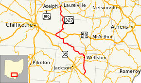
State Route 327 (SR 327) is a north–south state highway in the south central portion of the U.S. state of Ohio. Its southern terminus is at U.S. Route 35 (US 35) about seven miles (11 km) southeast of Jackson, at a one-quadrant interchange. It ends at its northern terminus at SR 180 in Adelphi.
| ||||
|---|---|---|---|---|
 | ||||
| Route information | ||||
| Maintained by ODOT | ||||
| Length | 47.35 mi[1] (76.20 km) | |||
| Existed | 1933–present | |||
| Major junctions | ||||
| South end | ||||
| ||||
| North end | ||||
| Location | ||||
| Counties | Jackson, Vinton, Ross, Hocking | |||
| Highway system | ||||
| ||||

History
SR 327 was commissioned in 1932, routed between Roads and Wellston.[2][3] In 1935 the highway was extended north to Adelphi.[4][5] The highway was extended south to US 35 in 1937.[6][7] In 2002, work began on replacing an at-grade intersection at SR 32 into an interchange south of Wellston. The $9 million project was funded jointly by the Federal Highway Safety Infrastructure program and ODOT's Highway Safety Program (HSP).[8] The project was completed in July 2004 at a cost of $12.5 million, an increase of $3.5 than originally estimated. It also rerouted SR 124 in a brief concurrency.[9]
Major intersections
| County | Location | mi[1] | km | Destinations | Notes | |||
|---|---|---|---|---|---|---|---|---|
| Jackson | Bloomfield Township | 0.00 | 0.00 | |||||
| Milton Township | 6.76 | 10.88 | Southern end of SR 124 concurrency | |||||
| 7.22– 7.33 | 11.62– 11.80 | Interchange, exit 17 (SR 32), northern end of SR 124 concurrency | ||||||
| Wellston | 8.93 | 14.37 | Southern end of SR 93 concurrency | |||||
| 9.79 | 15.76 | Northern end of SR 93 concurrency | ||||||
| Vinton | Harrison Township | 26.18 | 42.13 | Eastern end of US 50 concurrency | ||||
| Ross | Liberty Township | 30.21 | 48.62 | Western end of US 50 concurrency | ||||
| Vinton | Eagle Township | 33.29 | 53.58 | Western terminus of SR 671 | ||||
| Hocking |
No major junctions | |||||||
| Ross |
No major junctions | |||||||
| Hocking |
No major junctions | |||||||
| Ross | Adelphi | 47.35 | 76.20 | |||||
1.000 mi = 1.609 km; 1.000 km = 0.621 mi
| ||||||||
References
- Ohio Department of Transportation. "Technical Services Straight Line Diagrams". Retrieved April 30, 2010.
- Ohio Department of Highways (1931). Map of Ohio Showing State Highway System (PDF) (Map). 1:760,320. Columbus: Ohio Department of Highways. OCLC 5673562, 7231737. Retrieved October 29, 2013.
- Ohio Department of Highways (1932). Map of Ohio Showing State Highway System (PDF) (Map). 1:760,320. Columbus: Ohio Department of Highways. OCLC 5673562, 7231704. Retrieved October 29, 2013.
- Ohio Department of Highways (1934). Map of Ohio Showing State Highway System (PDF) (Map). 1:760,320. Columbus: Ohio Department of Highways. OCLC 5673562, 7236991. Retrieved October 29, 2013.
- Ohio Department of Highways (1935). Official Highway Map of Ohio (PDF) (Map). [1:760,320]. Columbus: Ohio Department of Highways. OCLC 5673562, 54667348. Retrieved October 29, 2013.
- Ohio Department of Highways (1936). Official Highway Map of Ohio (PDF) (Map). 1:760,320. Columbus: Ohio Department of Highways. OCLC 5673562. Retrieved October 29, 2013.
- Ohio Department of Highways (1937). Official Highway Map of Ohio (PDF) (Map). 1:760,320. Columbus: Ohio Department of Highways. OCLC 5673562, 16960304. Retrieved October 29, 2013.
- "Taft Marks Beginning of Wellston Interchange Project". Ohio Department of Transportation (ODOT). April 3, 2002. Retrieved February 20, 2020.
- "ODOT District 9 Major New Program" (PDF). ODOT District 9. August 5, 2008. Retrieved February 20, 2020.