Oakview, Queensland
Oakview is a locality in the Gympie Region, Queensland, Australia.[1] It is an historic mining area and now grazing country.
| Oakview Queensland | |||||||||||||||
|---|---|---|---|---|---|---|---|---|---|---|---|---|---|---|---|
 Oakview | |||||||||||||||
| Coordinates | 26°07′14″S 152°19′38″E | ||||||||||||||
| Postcode(s) | 4600 | ||||||||||||||
| Location | |||||||||||||||
| LGA(s) | Gympie Region | ||||||||||||||
| State electorate(s) | Nanango | ||||||||||||||
| Federal Division(s) | Wide Bay | ||||||||||||||
| |||||||||||||||
Geography
The southern half and northern edge of Oakview are mountainous with lower flatter land in-between. The lower land has an elevation of 100–150 metres above sea level and is used for grazing. The northern edge contains Sugarloaf Mountain (340 metres above sea level) and is undeveloped land. The southern half rises to an unnamed peak at 630 metres above sea level and is part of the Oakview State Forest and the Oakview National Park.[2]
Wide Bay Creek meanders from west to east through the northern flatter part of the locality; it is a tributary of the Mary River.[2]
The railway line from Theebine to Nanango passes from east to west through the locality through the flatter land, but the line is no longer operating. Oakview was served by the Oakview railway station (26°04′37″S 152°19′52″E).[3] The Wide Bay Highway runs from east to west through the flatter land to the south of the railway line.[2]
Ecology
The Oakview National Park contains a bottle tree (Brachychiton) scrub with two near-threatened flora: the giant ironwood Choricarpia subargentea and the Rhodamnia pauciovulata. It is also the habitat of the endangered gecko Phyllurus kabikabi and Nangur spiny skink Nangura spinosa.[4]
History
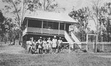
The Oakview Provisional School opened in 1895. It closed temporarily in 1901, reopening in 1902. In 1913, it became a half-time school, sharing its teacher with Running Creek Provisional School. In 1914 it resumed its full-time status but closed later that year. The school reopened as Oakview State School on 12 September 1918, but closed again in 1928. It reopened for the last time on 1 June 1937 as Oakview State School and closed permanently in 1963.[5]
Oakview sawmill was operated by the Spencer Brothers from 1934 to 1971. It was located near the Oakview railway station (26°04.8′S 152°19.9′E).[6]
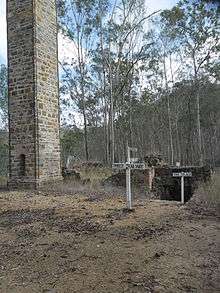
In 2001, 3,490ha of Oakview State Forest was converted to Oakview Forest Reserve in order to converse its ecosystem. In 2009, 1,011ha of the forest reserve was converted to Oakview National Park while the other 2,479ha became a Resource Reserve to allow mining exploration (the south-western area of the locality having been mined for copper in the 1860s and 1870s). After the mining exploration was completed, the resource reserve land was added to the converted to national park.[4]
Heritage listings
Oakview has the following heritage listings:
- Rossmore Road, in the upper reaches of Fat Hen Creek: Mount Clara smelter[7]
References
- "Oakview (entry 46372)". Queensland Place Names. Queensland Government. Retrieved 31 January 2017.
- "Queensland Globe". State of Queensland. Retrieved 31 January 2017.
- "Oakview - railway station (entry 25022)". Queensland Place Names. Queensland Government. Retrieved 1 February 2017.
- "Oakview National Park Management Statement 2013". Department of National Parks, Sport and Racing. Queensland Government. 22 November 2013. Retrieved 1 February 2017.
- Queensland Family History Society (2010), Queensland schools past and present (Version 1.01 ed.), Queensland Family History Society, ISBN 978-1-921171-26-0
- Kerr, John (1998), Forest industry heritage places study : sawmills and tramways, South Eastern Queensland (PDF), Queensland Government, p. 184, archived (PDF) from the original on 31 January 2017, retrieved 1 February 2017
- "Mount Clara Smelter (entry 600640)". Queensland Heritage Register. Queensland Heritage Council. Retrieved 1 August 2014.
External links
![]()