North Shore railway line
The North Shore Line is a railway line serving the North Shore in Sydney, New South Wales, Australia. The North Shore Line extends from Sydney Central station through the western limb of the City Circle, across the Sydney Harbour Bridge and through the North Shore area to Hornsby where it joins the Main North Line. Most services on the line are part of the T1 North Shore & Western Line, with some services to Wyong during peak hours.
| North Shore railway line | |||||||||||||||||||||||||||||||||||||||||||||||||||||||||||||||||||||||||||||||||||||||||||||||||||||||||||||||||||||||||||||||||||||||||||||||||||||||||||||||||||||||||||||||||||||||||||||||||||||||||||||||||||||||||||
|---|---|---|---|---|---|---|---|---|---|---|---|---|---|---|---|---|---|---|---|---|---|---|---|---|---|---|---|---|---|---|---|---|---|---|---|---|---|---|---|---|---|---|---|---|---|---|---|---|---|---|---|---|---|---|---|---|---|---|---|---|---|---|---|---|---|---|---|---|---|---|---|---|---|---|---|---|---|---|---|---|---|---|---|---|---|---|---|---|---|---|---|---|---|---|---|---|---|---|---|---|---|---|---|---|---|---|---|---|---|---|---|---|---|---|---|---|---|---|---|---|---|---|---|---|---|---|---|---|---|---|---|---|---|---|---|---|---|---|---|---|---|---|---|---|---|---|---|---|---|---|---|---|---|---|---|---|---|---|---|---|---|---|---|---|---|---|---|---|---|---|---|---|---|---|---|---|---|---|---|---|---|---|---|---|---|---|---|---|---|---|---|---|---|---|---|---|---|---|---|---|---|---|---|---|---|---|---|---|---|---|---|---|---|---|---|---|---|---|---|
 | |||||||||||||||||||||||||||||||||||||||||||||||||||||||||||||||||||||||||||||||||||||||||||||||||||||||||||||||||||||||||||||||||||||||||||||||||||||||||||||||||||||||||||||||||||||||||||||||||||||||||||||||||||||||||||
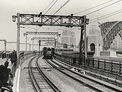
 First passenger train crossing the Sydney Harbour bridge, 19 March 1932. | |||||||||||||||||||||||||||||||||||||||||||||||||||||||||||||||||||||||||||||||||||||||||||||||||||||||||||||||||||||||||||||||||||||||||||||||||||||||||||||||||||||||||||||||||||||||||||||||||||||||||||||||||||||||||||
| Technical | |||||||||||||||||||||||||||||||||||||||||||||||||||||||||||||||||||||||||||||||||||||||||||||||||||||||||||||||||||||||||||||||||||||||||||||||||||||||||||||||||||||||||||||||||||||||||||||||||||||||||||||||||||||||||||
| Track gauge | 4 ft 8 1⁄2 in (1,435 mm) | ||||||||||||||||||||||||||||||||||||||||||||||||||||||||||||||||||||||||||||||||||||||||||||||||||||||||||||||||||||||||||||||||||||||||||||||||||||||||||||||||||||||||||||||||||||||||||||||||||||||||||||||||||||||||||
| |||||||||||||||||||||||||||||||||||||||||||||||||||||||||||||||||||||||||||||||||||||||||||||||||||||||||||||||||||||||||||||||||||||||||||||||||||||||||||||||||||||||||||||||||||||||||||||||||||||||||||||||||||||||||||
History

The North Shore Line was opened on 1 January 1890 as a single track between Hornsby and St Leonards. The line was extended to the Sydney Harbour foreshore at Milsons Point on 1 May 1893. Transport between this original Milsons Point station and central Sydney was by ferry boat. Most of the North Shore line was duplicated between 1900 and 1909. In 1927 the line was converted to electric operation using a 1500 volt DC, overhead supply.
The construction works for the Sydney Harbour Bridge necessitated truncation of the southern terminus from Milsons Point to Lavender Bay.
When the Sydney Harbour Bridge was opened on 19 March 1932 a new Milsons Point station (on the bridge approach) came into operation and the North Shore Line was extended through it and over the Sydney Harbour Bridge to link with the underground lines of central Sydney. The result is that the two ends of the North Shore Line link to the Sydney railway system at Central and Hornsby.
After 1932 the original Lavender Bay station became a storage depot for electric trains, and the line connecting Lavender Bay to the North Shore line was reduced to single track. This line joins the current North Shore line at Waverton station.
In 2009, a second connection to the Main Northern line was added with the opening to the Epping to Chatswood railway line. This connecting line was removed and incorporated into the Sydney Metro in 2019.
The North Shore Line is now a major commuter artery between the North Shore and central Sydney. In early years, Old Milsons Point, Bay Road, St Leonards, Chatswood, Lindfield, Gordon, Pymble, Turramurra, Wahroonga and Hornsby stations had goods yards. All but St Leonards, Chatswood and Hornsby yards had disappeared by mid-twentieth century, and the latter three did not survive into the late twentieth century.
Route
The North Shore line officially starts at Central, with a junction with the Main Suburban line south of the Flying Junctions. The line runs through Central, then goes underground alongside the City Circle, with stations at Town Hall and Wynyard. There is a crossover north of Wynyard allowing southbound trains to terminate when there is trackwork in the City Circle. After Wynyard, the line emerges onto the western side of the Sydney Harbour Bridge. On the other side of the bridge is Milsons Point station. The line continues for a short distance to North Sydney station, which has 4 platforms. The outer two tracks are for through services, while the inner two tracks are loop lines for terminating trains.[1]
After North Sydney, the line snakes its way through Sydney's lower North Shore, passing Waverton, Wollstonecraft, St Leonards and Artamon stations. At Waverton is the small junction with the Lavender Bay line, providing access to Lavender Bay/North Sydney Sidings. This section of line also has the sharpest curve on Sydney's suburban network, at Wollstonecraft of 10 chains (200 m).[2] At Chatswood, there are 4 platforms, with the inner two used by Sydney Metro Northwest and formerly to enter the Epping to Chatswood rail link.[1]
The line continues up the North Shore region, with stations at Roseville, Lindfield, Killara, Gordon, Pymble, Turramurra, Warrawee, Wahroonga and Waitara. Lindfield has an additional bay platform in the centre, used to terminate trains from the south. A similar arrangement exists at Gordon, where the centre platform is connected to a loop line that can terminate trains in both directions. After Waitara, the line proceeds to Hornsby, where there is a junction with the Main Northern Line and Hornsby Maintenance Centre.[1]
References
- Sydney Trains (2019). DRIVERS ROUTE KNOWLEDGE DIAGRAMS - North Shore Line Central to Hornsby (PDF).
- Rail Access Corporation. "Curve and Gradient Diagrams V2.0" (PDF). Transport for NSW. p. 105.