Barraba railway line
The Barraba branch railway line is a closed railway line in New South Wales, Australia. The line, which was opened on 21 September 1908,[1] ran for 99 kilometres (62 mi) north along the Manilla valley to the town of Barraba from the Main North railway line at West Tamworth.
| Barraba Line | ||||||||||||||||||||||||||||||||||||||||||||||||||||||||||||||||||||||||||||||||||||||||||||||||||||||||||||||||||||||||
|---|---|---|---|---|---|---|---|---|---|---|---|---|---|---|---|---|---|---|---|---|---|---|---|---|---|---|---|---|---|---|---|---|---|---|---|---|---|---|---|---|---|---|---|---|---|---|---|---|---|---|---|---|---|---|---|---|---|---|---|---|---|---|---|---|---|---|---|---|---|---|---|---|---|---|---|---|---|---|---|---|---|---|---|---|---|---|---|---|---|---|---|---|---|---|---|---|---|---|---|---|---|---|---|---|---|---|---|---|---|---|---|---|---|---|---|---|---|---|---|---|
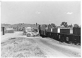
 Loading containers of asbestos into rail wagons in Barraba yard | ||||||||||||||||||||||||||||||||||||||||||||||||||||||||||||||||||||||||||||||||||||||||||||||||||||||||||||||||||||||||
| Technical | ||||||||||||||||||||||||||||||||||||||||||||||||||||||||||||||||||||||||||||||||||||||||||||||||||||||||||||||||||||||||
| Track gauge | 1,435 mm (4 ft 8 1⁄2 in) | |||||||||||||||||||||||||||||||||||||||||||||||||||||||||||||||||||||||||||||||||||||||||||||||||||||||||||||||||||||||
| ||||||||||||||||||||||||||||||||||||||||||||||||||||||||||||||||||||||||||||||||||||||||||||||||||||||||||||||||||||||||
The railway line crossed the Namoi River at Manilla over a large viaduct and crosses the Peel River just before Attunga. Two Howe timber truss bridges, one over Borah Creek in Upper Manilla (575 km from Sydney Central) and the other over Oakey Creek between Manilla and Attunga (539km), are heritage listed.[2]
In the 1970s, the Barraba line was served by the unique railmotor, CHP38 (also known as Creamy Kate).[3] At that period, large quantities of asbestos was railed from Barraba in containers for export.
The line is now open for only 6 kilometres (4 mi) for use as grain wagon storage.[1]
A stop block is in place at Dampier Street, Tamworth and the line was damaged by flood along Wallamore Road on 29 November 2008
On 24 November 2017 it was announced that the line from West Tamworth to Westdale silos would be rebuilt for a new freight centre.
References
- Barraba branch - NSWrail.net
- "Manilla railway underbridges". New South Wales State Heritage Register. Office of Environment and Heritage. H01045. Retrieved 16 July 2018.
- Return Trip to Barraba in CHP38 Blackwell, Greg Australian Railway Historical Society Bulletin, July, 2000 pp259-266