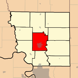
Nodaway Township, Andrew County, Missouri
Nodaway Township is one of ten townships in Andrew County, Missouri, United States. As of the 2010 census, its population was 6,738.[3]
Nodaway Township | |
|---|---|
 | |
| Coordinates: 39°56′44″N 094°49′39″W | |
| Country | United States |
| State | Missouri |
| County | Andrew |
| Area | |
| • Total | 39.41 sq mi (102.08 km2) |
| • Land | 39.01 sq mi (101.04 km2) |
| • Water | 0.40 sq mi (1.04 km2) 1.02% |
| Elevation | 1,109 ft (338 m) |
| Population (2010) | |
| • Total | 6,738 |
| • Density | 173/sq mi (66.7/km2) |
| FIPS code | 29-52688[2] |
| GNIS feature ID | 0766227 |
Nodaway Township was established in 1846, and named after the Nodaway River.[4]
Geography
Nodaway Township covers an area of 39.4 square miles (102.1 km2) and contains one incorporated settlement, Savannah (the county seat). It contains four cemeteries: Bennett Lane, Coffman, Earls and Kellogg.
The streams of Honey Creek and Lincoln Creek run through this township.
Transportation
Nodaway Township contains one airport, Worth Airport.
gollark: Huh, turns out Gitea has a thing where I can have custom reactions.
gollark: It supports forms too and if msgpack or something were popular it could do that fine.
gollark: I can just do `http POST https://osmarks.tk/json-thing bees=4 unbees=5`.
gollark: I have an API test tool which is mildly nicer than writing JSON would be.
gollark: [REDACTED], as the cool kids say.
References
- "US Board on Geographic Names". United States Geological Survey. 2007-10-25. Retrieved 2008-01-31.
- "U.S. Census website". United States Census Bureau. Retrieved 2008-01-31.
- "Geographic Identifiers: 2010 Demographic Profile Data (G001): Nodaway township, Andrew County, Missouri". U.S. Census Bureau, American Factfinder. Archived from the original on February 12, 2020. Retrieved June 21, 2013.
- "Andrew County Place Names, 1928-1945 (archived)". The State Historical Society of Missouri. Archived from the original on 24 June 2016. Retrieved 30 August 2016.CS1 maint: BOT: original-url status unknown (link)
External links
Municipalities and communities of Andrew County, Missouri, United States | ||
|---|---|---|
| Cities | 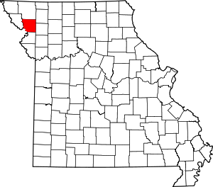 Map of Missouri highlighting Andrew County | |
| Villages | ||
| Townships | ||
| Unincorporated communities | ||
| Ghost towns | ||
This article is issued from Wikipedia. The text is licensed under Creative Commons - Attribution - Sharealike. Additional terms may apply for the media files.