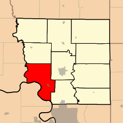
Lincoln Township, Andrew County, Missouri
Lincoln Township is one of ten townships in Andrew County, Missouri, United States. As of the 2010 census, its population was 1,184.[3]
Lincoln Township | |
|---|---|
 | |
| Coordinates: 39°55′28″N 094°55′20″W | |
| Country | United States |
| State | Missouri |
| County | Andrew |
| Area | |
| • Total | 44.46 sq mi (115.15 km2) |
| • Land | 43.79 sq mi (113.42 km2) |
| • Water | 0.67 sq mi (1.73 km2) 1.50% |
| Elevation | 1,004 ft (306 m) |
| Population (2010) | |
| • Total | 1,184 |
| • Density | 27/sq mi (10.4/km2) |
| FIPS code | 29-42572[2] |
| GNIS feature ID | 0766225 |
Lincoln Township was named after John Lincoln, a member of the Lincoln family who settled the area.[4]
Geography
Lincoln Township covers an area of 44.46 square miles (115.15 km2) and contains one incorporated municipality, Amazonia. It contains three cemeteries: Greenwick, Hackberry, and Old Union.
The streams of Caples Creek, Hopkins Creek, Mill Creek, and the Nodaway River run through this township.
gollark: Yes. My phone I'd hard to type on.
gollark: !pass 213
gollark: !help
gollark: Okay, we have 12 active players, and 6 votes in favour of #213 right now. By section 2.2.3's "A majority of active players have voted in favour of the proposal, and there are more than 2 active players" option I believe this allows me to pass it.
gollark: !activity
References
- "US Board on Geographic Names". United States Geological Survey. 2007-10-25. Retrieved 2008-01-31.
- "U.S. Census website". United States Census Bureau. Retrieved 2008-01-31.
- "Geographic Identifiers: 2010 Demographic Profile Data (G001): Lincoln township, Andrew County, Missouri". U.S. Census Bureau, American Factfinder. Archived from the original on February 12, 2020. Retrieved June 21, 2013.
- "Andrew County Place Names, 1928-1945 (archived)". The State Historical Society of Missouri. Archived from the original on 24 June 2016. Retrieved 30 August 2016.CS1 maint: BOT: original-url status unknown (link)
External links
Municipalities and communities of Andrew County, Missouri, United States | ||
|---|---|---|
| Cities | 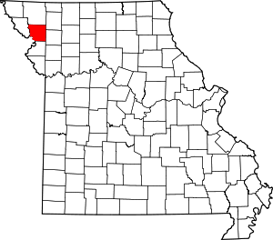 Map of Missouri highlighting Andrew County | |
| Villages | ||
| Townships | ||
| Unincorporated communities | ||
| Ghost towns | ||
This article is issued from Wikipedia. The text is licensed under Creative Commons - Attribution - Sharealike. Additional terms may apply for the media files.