Nicolas de Fer
Nicolas de Fer (1646 – 25 October 1720) was a French cartographer and geographer. He also was an engraver and publisher. His works focused more on quantity than quality, there were often geographical errors,[1] and they were more artistic than accurate.[2]
Nicolas de Fer | |
|---|---|
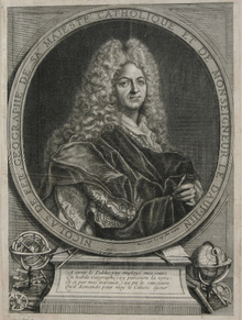 Engraving of Nicolas de Fer by Jaques-François Bénard | |
| Born | 1646 |
| Died | 25 October 1720 (aged 74) Paris, France |
| Nationality | French |
| Occupation | cartographer, geographer, engraver, publisher |
| Parent(s) | Antoine and Geneviève |
Early life
De Fer was the youngest of three sons of Antoine de Fer, who was also a cartographer.[3] When he was 12, he became the apprentice of Parisian engraver Louis Spirinx, and made his first map, of the Canal du Midi, at the age of 23.[4] After the death of his father in June 1673, his mother Geneviève initially took over the map making company, which had begun to decline.[5] She passed it and the atelier, called Quai de L'Horloge, on to Nicolas in 1687 because of her old age.[5]
Career
De Fer was so successful at improving the firm that, in 1690, he became the official geographer to Louis, Dauphin of France.[6] With support from the Spanish and French royal families, de Fer also became official geographer for Philip V and Louis XIV, the kings of Spain and France, respectively.[3][5] Because of this, his maps became Bourbon propaganda, endorsing French King Louis XIV.[5][6]
His business flourished, producing town plans, atlases, wall maps, and more than 600 sheet maps.[3] He made maps of places in Europe and North America, including New Spain,[7] places fortified by Vauban,[8] the Low Countries, and the War of the Spanish Succession. In 1698, de Fer published a map of North America, which included a depiction of beavers building dams near Niagara Falls. Seventeen years later, Herman Moll published a map which plagiarized elements of de Fer's work, particularly the beaver scene. It became known as the "Beaver map".[9][10] De Fer became the official geographer for The King of Spain in 1720.[6] Two of his sons-in-law, Guillaume Danet and Jaques-François Bénard, continued the company after de Fer's death on 25 October of that year until around 1760.[1]
Major works
- Les Côtes de France (1690)
- La France triomphante sous le règne de Louis le Grand (1693)
- Atlas Royal (first ed. 1695)
- Petit et Nouveau Atlas (1697)
- Atlas curieux (1700)
- Atlas ou recueil de cartes géographiques dressées sur les nouvelles observations (1709)
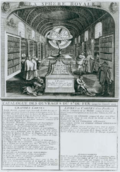
- La Sphère Royale (1717)
See also
References
- "The De Fer Family". Geographicus. Archived from the original on 16 February 2013. Retrieved 5 January 2013.
- "Cartographers". Mapcarte.com. Archived from the original on 30 July 2012. Retrieved 5 January 2013.
- Kanas, Nick (2012). Star Maps: History, Artistry, and Cartography (2nd ed.). Springer. pp. 214–215. doi:10.1007/978-1-4614-0917-5. ISBN 978-1-4614-0916-8. Retrieved 4 January 2013.
- "Nicolas de Fer". Mapping the past: Rare Russian maps from special collections. University of Missouri. June 30, 2011. Retrieved 5 January 2013.
- Barron, Roderick M. "Fer, Nicolas de [1646-1720]". Retrieved 4 January 2013.
- "Nicolas de Fer". Artfact. Archived from the original on 15 February 2013. Retrieved 5 January 2013.
- Eccles, J. W. (1997). Allen, John Logan (ed.). North American Exploration: A Continent Defined. 2. University of Nebraska Press. p. 149. ISBN 0-8032-1023-X. Retrieved 5 January 2013.
- Ostwald, Jamel (2007). Vauban Under Siege: Engineering Efficiency and Martial Vigor in the War of the Spanish Succession. Brill. p. 60. ISBN 90-04-15489-2.
- "Detecting the Truth: Fakes, Forgeries and Trickery". Library and Archives Canada. Archived from the original on 24 October 2018. Retrieved 6 January 2013.
- "Herman Moll". Mapping the past: Rare Russian maps from special collections. University of Missouri. June 30, 2011. Retrieved 6 January 2013.
External links
| Wikimedia Commons has media related to Nicolas de Fer. |
- 1685 miniature map of India
- List of maps by De Fer Eran Laor Cartographic Collection, The National Library of Israel.
- Map of the Church of Holy Sepulchre, 1715. Eran Laor Cartographic Collection. The National Library of Israel.
| Authority control |
|---|