New Hope, Oregon
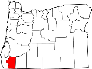
New Hope is an unincorporated community and census-designated place (CDP) in Josephine County, Oregon, United States.[1] As of the 2010 census it had a population of 1,515.[2]
New Hope, Oregon | |
|---|---|
 New Hope  New Hope | |
| Coordinates: 42.362°N 123.368°W | |
| Country | United States |
| State | Oregon |
| County | Josephine |
| Area | |
| • Total | 3.83 sq mi (9.91 km2) |
| • Land | 3.83 sq mi (9.91 km2) |
| • Water | 0.0 sq mi (0.0 km2) |
| Elevation | 1,040 ft (320 m) |
| Population (2010) | |
| • Total | 1,515 |
| • Density | 396/sq mi (152.8/km2) |
| Time zone | UTC-8 (Pacific (PST)) |
| • Summer (DST) | UTC-7 (PDT) |
| ZIP code | 97527 |
| Area code(s) | 458 and 541 |
| FIPS code | 41-52275 |
| GNIS feature ID | 1146811 |
Geography
New Hope is in eastern Josephine County, 6 miles (10 km) south of Grants Pass, the county seat. The community lies just north of the Applegate River, a northwest-flowing tributary of the Rogue River.
According to the U.S. Census Bureau, the New Hope CDP has an area of 3.8 square miles (9.9 km2), all of it recorded as land.[2]
gollark: <@301477111229841410> It's not efficient. You would probably get more energy just burning the extra food or something. Also, the prisoners wouldn't like it.
gollark: *Negative* oil prices? Surely that'sa bug.
gollark: But anarchism doesn't have government! CHECKMATE, ATHEISTS!
gollark: I mean, Ethernet can do 10Gbps over... eight wires, is it?
gollark: I think the problem is more that university education seems to suffer stupidly high costs for some mysterious reason, and throwing giant amounts of tax money is unlikely to help.
References
- http://oregon.hometownlocator.com/or/Josephine/New-Hope.cfm
- "Geographic Identifiers: 2010 Census Summary File 1 (G001): New Hope CDP, Oregon". American Factfinder. U.S. Census Bureau. Archived from the original on February 13, 2020. Retrieved November 1, 2018.
This article is issued from Wikipedia. The text is licensed under Creative Commons - Attribution - Sharealike. Additional terms may apply for the media files.
