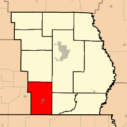
Neely Township, Butler County, Missouri
Neely Township is one of ten townships in Butler County, Missouri, USA. As of the 2000 census, its population was 1,259.
Neely Township | |
|---|---|
 | |
| Coordinates: 36°33′47″N 090°31′06″W | |
| Country | United States |
| State | Missouri |
| County | Butler |
| Area | |
| • Total | 59.9 sq mi (155.15 km2) |
| • Land | 59.86 sq mi (155.05 km2) |
| • Water | 0.04 sq mi (0.1 km2) 0.06% |
| Elevation | 302 ft (92 m) |
| Population (2000) | |
| • Total | 1,259 |
| • Density | 21/sq mi (8.1/km2) |
| FIPS code | 29-51392[2] |
| GNIS feature ID | 0766355 |
Neely Township was organized in 1871, and named after Obadiah Neely, an early citizen.[3]
Geography
Neely Township covers an area of 59.9 square miles (155 km2) and contains one incorporated settlement, Neelyville. It contains seven cemeteries: Crab, Harris Ridge, Lutz, Neeleyville, Roberts, Sheely and Sims.
The streams of Big Cane Creek, Cane Creek, Cope Branch, Fox Branch and Gaines Slough run through this township.
Transportation
Neely Township contains one airport or landing strip: Wattle Landing Strip.
gollark: Antigollark (quaternionic), you mean.
gollark: There's a two-layer recursion limit because only ABR responds to bots.
gollark: However, it is already too late.
gollark: Great!
gollark: I prefer technetium in general however.
References
- "US Board on Geographic Names". United States Geological Survey. 2007-10-25. Retrieved 2008-01-31.
- "U.S. Census website". United States Census Bureau. Retrieved 2008-01-31.
- "Butler County Place Names, 1928–1945 (archived)". The State Historical Society of Missouri. Archived from the original on 24 June 2016. Retrieved 6 September 2016.CS1 maint: BOT: original-url status unknown (link)
External links
Municipalities and communities of Butler County, Missouri, United States | ||
|---|---|---|
| Cities | 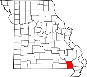 Map of Missouri highlighting Butler County | |
| Townships | ||
| CDP | ||
| Other unincorporated communities | ||
| Ghost town | ||
| Footnotes | ‡This populated place also has portions in an adjacent county or counties | |
This article is issued from Wikipedia. The text is licensed under Creative Commons - Attribution - Sharealike. Additional terms may apply for the media files.