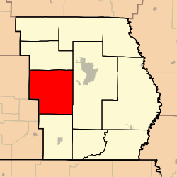
Beaver Dam Township, Butler County, Missouri
Beaver Dam Township is one of ten townships in Butler County, Missouri, USA. As of the 2000 census, its population was 3,963.
Beaver Dam Township | |
|---|---|
 | |
| Coordinates: 36°43′40″N 090°20′08″W | |
| Country | United States |
| State | Missouri |
| County | Butler |
| Area | |
| • Total | 76.01 sq mi (196.86 km2) |
| • Land | 75.92 sq mi (196.64 km2) |
| • Water | 0.08 sq mi (0.21 km2) 0.11% |
| Elevation | 325 ft (99 m) |
| Population (2000) | |
| • Total | 3,963 |
| • Density | 52.2/sq mi (20.2/km2) |
| FIPS code | 29-03826[2] |
| GNIS feature ID | 0766349 |
Geography
Beaver Dam Township covers an area of 76.01 square miles (196.9 km2) and contains no incorporated settlements. It contains nine cemeteries: Bay Springs, Cochran, Dickens, Dunning, Hudgens, Kinsey, Lone Hill, Military and Montgomery.
The streams of Beaverdam Creek, Case Bolt Branch, Dolly Branch, Fletcher Branch, Haw Branch, Kenner Spring Branch and Wolf Creek run through this township.
gollark: ... and what's mcleak?
gollark: MCLeaks?
gollark: h4xx0r1ng.
gollark: The responsible disclosure one, I mean.
gollark: … *rules*
References
- "US Board on Geographic Names". United States Geological Survey. 2007-10-25. Retrieved 2008-01-31.
- "U.S. Census website". United States Census Bureau. Retrieved 2008-01-31.
External links
Municipalities and communities of Butler County, Missouri, United States | ||
|---|---|---|
| Cities | 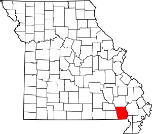 Map of Missouri highlighting Butler County | |
| Townships | ||
| CDP | ||
| Other unincorporated communities | ||
| Ghost town | ||
| Footnotes | ‡This populated place also has portions in an adjacent county or counties | |
This article is issued from Wikipedia. The text is licensed under Creative Commons - Attribution - Sharealike. Additional terms may apply for the media files.