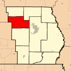
Epps Township, Butler County, Missouri
Epps Township is one of ten townships in Butler County, Missouri, USA. As of the 2000 census, its population was 2,598.
Epps Township | |
|---|---|
 | |
| Coordinates: 36°48′38″N 090°33′07″W | |
| Country | United States |
| State | Missouri |
| County | Butler |
| Area | |
| • Total | 53.84 sq mi (139.45 km2) |
| • Land | 53.79 sq mi (139.31 km2) |
| • Water | 0.06 sq mi (0.14 km2) 0.1% |
| Elevation | 522 ft (159 m) |
| Population (2000) | |
| • Total | 2,598 |
| • Density | 48.3/sq mi (18.6/km2) |
| FIPS code | 29-22492[2] |
| GNIS feature ID | 0766353 |
Epps Township was established in 1850, and named after Obadiah Epps, an early settler.[3]
Geography
Epps Township covers an area of 53.84 square miles (139.4 km2) and contains no incorporated settlements. It contains three cemeteries: Houts, Kearbey and Sparkman.
The streams of Beehole Branch, Camp Branch, Crooked Branch, Goose Creek, Harmon Branch, Hurricane Creek and Procter Branch run through this township.
gollark: You couldn't keep up with the highly overclocked legalistic processing processors anyway.
gollark: I sometimes disable my memory of them for legal reasons.
gollark: Odd.
gollark: Which is also where your computer is?
gollark: Interesting.
References
- "US Board on Geographic Names". United States Geological Survey. 2007-10-25. Retrieved 2008-01-31.
- "U.S. Census website". United States Census Bureau. Retrieved 2008-01-31.
- "Butler County Place Names, 1928–1945 (archived)". The State Historical Society of Missouri. Archived from the original on 24 June 2016. Retrieved 6 September 2016.CS1 maint: BOT: original-url status unknown (link)
Ten Mile Creek runs through Epps Township, Butler County, Missouri. The Kearbey Cemetery is actually Kearbey Chapel Cemetery.
External links
Municipalities and communities of Butler County, Missouri, United States | ||
|---|---|---|
| Cities | 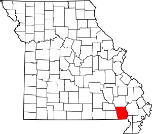 Map of Missouri highlighting Butler County | |
| Townships | ||
| CDP | ||
| Other unincorporated communities | ||
| Ghost town | ||
| Footnotes | ‡This populated place also has portions in an adjacent county or counties | |
This article is issued from Wikipedia. The text is licensed under Creative Commons - Attribution - Sharealike. Additional terms may apply for the media files.