National Route 4 (Costa Rica)
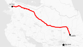
National Primary Route 4, or Route 4, officially known as Corredor Noratlántico (North Atlantic Drive) is a national primary road, which covers the northern region of the country, through the provinces of Limón, Heredia, Alajuela and Guanacaste.
| ||||
|---|---|---|---|---|
| Ruta Nacional Primaria 4 | ||||
| Corredor Noratlántico North Atlantic Drive | ||||
 | ||||
| Route information | ||||
| Maintained by the MOPT | ||||
| Length | 255 km (158 mi) | |||
| History | Finished August 2017 | |||
| Major junctions | ||||
| West end | ||||
| East end | ||||
| Location | ||||
| Provinces | Alajuela, Heredia, Guanacaste, Limón | |||
| Highway system | ||||
National Road Network of Costa Rica
| ||||
Description
Route 4 covers the north provinces of the country, and allows to travel between the Pacific Ocean districts and the Caribbean side of the country without going through the Greater Metropolitan Area at the central valley.
Together with Route 32, it forms the northwest end of the Corredor Norte-Caribe (North-Caribbean Drive), which allows to traverse the country from the Pacific Ocean to the Caribbean sea.
According to National Laboratory of Materials and Structural Models (LANAMME) at the University of Costa Rica, Route 4 is not safe for the high vehicular traffic expected, and an intervention is required for further safety for pedestrians, cyclists, and inhabitants of the small villages along the road.[1]
In Alajuela province the route covers San Carlos canton (Florencia, Aguas Zarcas, Pital, La Fortuna, La Palmera, Venado, Cutris, Monterrey districts), Upala canton (Upala, San José o Pizote, Delicias, Dos Ríos, Yolillal districts), Guatuso canton (San Rafael, Buenavista, Katira districts), Río Cuarto canton (Santa Rita district).
In Heredia province the route covers Sarapiquí canton (Puerto Viejo, La Virgen, Horquetas districts).
In Guanacaste province the route covers La Cruz canton (La Cruz, Santa Cecilia, Garita districts).
In Limón province the route covers Pococí canton (Guápiles district).
History
Road construction from Bajos de Chilamate to Vuelta de Kooper
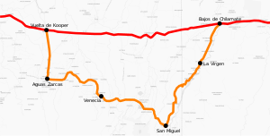
This is a segment planned since 1973, but construction started until 2013 and was opened in August 2017, it directly connects the then two endpoints of Route 4, at Bajos de Chilamate in Heredia province and Vuelta de Kooper in Alajuela province with a road of 27 km, single lane in each direction, and avoids the previous longer journey of 87.32 km which went through Route 126, Route 140, Route 250 and Route 751, and the towns of La Virgen, San Miguel, Venecia and Aguas Zarcas. This last segment finally concludes the construction of the originally planned Route 4.[2]
The new section road includes eight major bridges, five junctions at ground level and five elevated bypasses.[3]
Works were financed by Development Bank of Latin America, the central government and municipalities of San Carlos, Grecia, Sarapiquí and the regional North Huetar Special Economic Zone.[4][5]

References
- "Corredor Norte‐Caribe de Costa Rica" (PDF). LANAMME.
- Garro-Mora, José Francisco; Valverde-Cordero, Christian; Barrantes-Jiménez, Roy. "Evaluación de la Ruta Nacional 4, tramo entre los poblados de Bajos de Chilamate y Vuelta de Kooper, Costa Rica". LANAMMEUCR. Retrieved 13 September 2019.
- Madrigal, Luis Manuel (2017-08-23). "Tras 44 años de espera, Solís inaugura ruta Bajos de Chilamate-Vuelta de Kopper" (in Spanish). Retrieved 12 September 2019.
- "Zona Económica Especial Región Huetar Norte". Retrieved 12 September 2019.
- Chinchilla, Sofía. "Choferes se ahorrarán 60 km con nueva vía entre Chilamate y Vuelta de Kooper" (in Spanish).
