National Register of Historic Places listings in Teller County, Colorado
This is a list of the National Register of Historic Places listings in Teller County, Colorado.
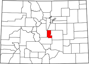
Location of Teller County in Colorado
This is intended to be a complete list of the properties and districts on the National Register of Historic Places in Teller County, Colorado, United States. The locations of National Register properties and districts for which the latitude and longitude coordinates are included below, may be seen in a map.[1]
There are 10 properties and districts listed on the National Register in the county, including 1 National Historic Landmark.
- This National Park Service list is complete through NPS recent listings posted August 14, 2020.[2]
| Adams - Alamosa - Arapahoe - Archuleta - Baca - Bent - Boulder - Broomfield - Chaffee - Cheyenne - Clear Creek - Conejos - Costilla - Crowley - Custer - Delta - Denver - Dolores - Douglas - Eagle - El Paso - Elbert - Fremont - Garfield - Gilpin - Grand - Gunnison - Hinsdale - Huerfano - Jackson - Jefferson - Kiowa - Kit Carson - La Plata - Lake - Larimer - Las Animas - Lincoln - Logan - Mesa - Mineral - Moffat - Montezuma - Montrose - Morgan - Otero - Ouray - Park - Phillips - Pitkin - Prowers - Pueblo - Rio Blanco - Rio Grande - Routt - Saguache - San Juan - San Miguel - Sedgwick - Summit - Teller - Washington - Weld - Yuma |
Current listings
| [3] | Name on the Register[4] | Image | Date listed[5] | Location | City or town | Description |
|---|---|---|---|---|---|---|
| 1 | Cripple Creek Historic District | 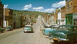 Cripple Creek Historic District |
October 15, 1966 (#66000939) |
State Highway 67 38°45′07″N 105°10′31″W |
Cripple Creek | |
| 2 | Florissant School | 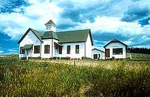 Florissant School |
October 1, 1990 (#90001503) |
2009 County Road 31 38°56′54″N 105°17′41″W |
Florissant | |
| 3 | Goldfield City Hall and Fire Station | 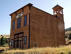 Goldfield City Hall and Fire Station |
May 17, 1984 (#84000897) |
Victor Ave. and 9th St. 38°43′06″N 105°07′25″W |
Goldfield | |
| 4 | Hornbek House | 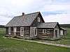 Hornbek House |
December 8, 1981 (#81000105) |
County Road 1 38°55′34″N 105°16′56″W |
Florissant | |
| 5 | Manitou Experimental Forest Station | 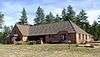 Manitou Experimental Forest Station |
August 28, 1998 (#98001091) |
232 County Road 79 39°06′00″N 105°05′30″W |
Woodland Park | |
| 6 | Midland Terminal Railroad Depot | .JPG) Midland Terminal Railroad Depot |
May 17, 1984 (#84000899) |
230 N. 4th St. 38°42′45″N 105°08′25″W |
Victor | |
| 7 | Stratton's Independence Mine and Mill | 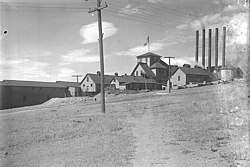 Stratton's Independence Mine and Mill |
March 4, 1993 (#93000054) |
Junction of Rangeview Rd. and State Highway 67 38°42′39″N 105°08′00″W |
Victor | |
| 8 | Twin Creek Ranch | 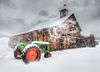 Twin Creek Ranch |
February 7, 1997 (#97000029) |
1465 Teller County Road 31 38°57′04″N 105°18′09″W |
Florissant | |
| 9 | Victor Downtown Historic District | 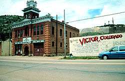 Victor Downtown Historic District |
July 3, 1985 (#85001463) |
Roughly bounded by Diamond Ave., 2nd, Portland, and 5th Sts. 38°42′39″N 105°08′25″W |
Victor | |
| 10 | Victor Hotel |  Victor Hotel |
April 10, 1980 (#80000929) |
4th St. and Victor Ave. 38°42′38″N 105°08′26″W |
Victor |
gollark: ```pythonprint(9**9**9**9)```
gollark: 15 might be interesting, I think my simple approach might dominate there.
gollark: 100 chars is perhaps too high, you can do a *lot*.
gollark: Er, not arbitrary precision, just arbitrarily large ints.
gollark: Especially with Python arbitrary precision arithmetic.
See also
| Wikimedia Commons has media related to National Register of Historic Places in Teller County, Colorado. |
References
- The latitude and longitude information provided in this table was derived originally from the National Register Information System, which has been found to be fairly accurate for about 99% of listings. Some locations in this table may have been corrected to current GPS standards.
- "National Register of Historic Places: Weekly List Actions". National Park Service, United States Department of the Interior. Retrieved on August 14, 2020.
- Numbers represent an ordering by significant words. Various colorings, defined here, differentiate National Historic Landmarks and historic districts from other NRHP buildings, structures, sites or objects.
- "National Register Information System". National Register of Historic Places. National Park Service. July 9, 2010.
- The eight-digit number below each date is the number assigned to each location in the National Register Information System database, which can be viewed by clicking the number.
| Topics | |
|---|---|
| Lists by state |
|
| Lists by insular areas | |
| Lists by associated state | |
| Other areas | |
| Related | |
| |
Municipalities and communities of Teller County, Colorado, United States | ||
|---|---|---|
| Cities | Map of Colorado highlighting Teller County | |
| Town | ||
| CDPs | ||
| Unincorporated community | ||
| Ghost towns | ||
| Footnotes | ‡This populated place also has portions in an adjacent county or counties | |
This article is issued from Wikipedia. The text is licensed under Creative Commons - Attribution - Sharealike. Additional terms may apply for the media files.