National Register of Historic Places listings in Knott County, Kentucky
This is a list of the National Register of Historic Places listings in Knott County, Kentucky.

Location of Knott County in Kentucky
It is intended to be a complete list of the properties on the National Register of Historic Places in Knott County, Kentucky, United States. The locations of National Register properties for which the latitude and longitude coordinates are included below, may be seen in a map.[1]
There are 5 properties listed on the National Register in the county.
- This National Park Service list is complete through NPS recent listings posted August 14, 2020.[2]
Current listings
| [3] | Name on the Register | Image | Date listed[4] | Location | City or town | Description |
|---|---|---|---|---|---|---|
| 1 | Bolen Building | 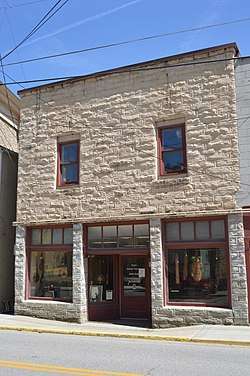 Bolen Building |
July 11, 2007 (#07000676) |
85 W. Main St. 37°20′05″N 82°58′55″W |
Hindman | |
| 2 | Hindman Ben Franklin | 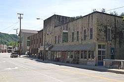 Hindman Ben Franklin |
August 23, 2007 (#07000675) |
16 W. Main St. 37°20′08″N 82°58′54″W |
Hindman | |
| 3 | Hindman Historic District |  Hindman Historic District |
March 27, 2013 (#13000112) |
Along Main St. and Kentucky Route 160 37°20′07″N 82°58′52″W |
Hindman | |
| 4 | Hiram and Art Stamper House | January 8, 2014 (#13001053) |
864 Stamper Branch Rd. 37°22′38″N 82°57′37″W |
Hindman | ||
| 5 | Wolfpen | January 7, 2014 (#12001200) |
105 Dead Mare Branch 37°14′19″N 82°55′28″W |
Mallie |
gollark: This is* a good use of storage.
gollark: This is why I just download all good videos I watch.
gollark: Ah, a primitive BundleNet precursor.
gollark: I'm sure you'd like me to think so.
gollark: Sure, but you have to live in Turkey.
See also
| Wikimedia Commons has media related to National Register of Historic Places in Knott County, Kentucky. |
References
- The latitude and longitude information provided in this table was derived originally from the National Register Information System, which has been found to be fairly accurate for about 99% of listings. Some locations in this table may have been corrected to current GPS standards.
- "National Register of Historic Places: Weekly List Actions". National Park Service, United States Department of the Interior. Retrieved on August 14, 2020.
- Numbers represent an ordering by significant words. Various colorings, defined here, differentiate National Historic Landmarks and historic districts from other NRHP buildings, structures, sites or objects.
- The eight-digit number below each date is the number assigned to each location in the National Register Information System database, which can be viewed by clicking the number.
| Topics | |
|---|---|
| Lists by state |
|
| Lists by insular areas | |
| Lists by associated state | |
| Other areas | |
| Related | |
| |
Municipalities and communities of Knott County, Kentucky, United States | ||
|---|---|---|
| Cities | Location of Knott County, Kentucky | |
| Unincorporated communities | ||
| Footnotes | ‡This populated place also has portions in an adjacent county or counties. | |
This article is issued from Wikipedia. The text is licensed under Creative Commons - Attribution - Sharealike. Additional terms may apply for the media files.