National Register of Historic Places listings in Henry County, Kentucky
This is a list of the National Register of Historic Places listings in Henry County, Kentucky.

Location of Henry County in Kentucky
It is intended to be a complete list of the properties and districts on the National Register of Historic Places in Henry County, Kentucky, United States. The locations of National Register properties and districts for which the latitude and longitude coordinates are included below, may be seen in an online map.[1]
There are 12 properties and districts listed on the National Register in the county.
- This National Park Service list is complete through NPS recent listings posted August 14, 2020.[2]
Current listings
| [3] | Name on the Register | Image | Date listed[4] | Location | City or town | Description |
|---|---|---|---|---|---|---|
| 1 | Callaway-Goodridge-Robertson Farm | February 3, 2010 (#09001308) |
6041 Kentucky Route 1861 38°23′00″N 85°16′03″W |
Smithfield | ||
| 2 | Confederate Soldiers Martyrs Monument in Eminence | 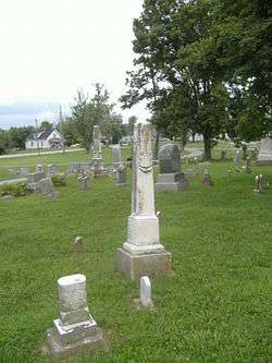 Confederate Soldiers Martyrs Monument in Eminence |
July 17, 1997 (#97000692) |
Eminence Cemetery, 2 miles south of the junction of Kentucky Routes 22 and 55 38°21′34″N 85°10′51″W |
Eminence | |
| 3 | Crutcher House | 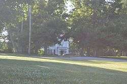 Crutcher House |
December 8, 1980 (#80001550) |
Mulberry Pike 38°21′36″N 85°10′15″W |
Eminence | |
| 4 | Eminence Historic Commercial District | 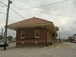 Eminence Historic Commercial District |
February 9, 1979 (#79000994) |
Broadway, Main and Penn Sts. 38°22′11″N 85°10′48″W |
Eminence | |
| 5 | Isham Henderson House | January 8, 1987 (#87000156) |
Main Cross Rd. 38°26′11″N 85°09′36″W |
New Castle | ||
| 6 | Henry County Courthouse, Jail, and Warden's House | 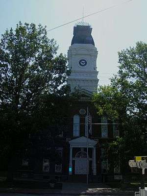 Henry County Courthouse, Jail, and Warden's House |
April 11, 1977 (#77000621) |
Courthouse Sq. 38°26′02″N 85°10′09″W |
New Castle | |
| 7 | Samuel Hieatt House | October 29, 1982 (#82001569) |
North of Smithfield on Hieatt Rd. 38°25′03″N 85°15′28″W |
Smithfield | ||
| 8 | Highlands | July 9, 1979 (#79000995) |
Southwest of Smithfield on Kentucky Route 22 38°21′59″N 85°16′47″W |
Smithfield | ||
| 9 | New Castle Historic Commercial District | August 4, 2016 (#16000495) |
Main & Main Cross Sts. 38°26′00″N 85°10′12″W |
New Castle | ||
| 10 | Robert Ricketts House | July 12, 1978 (#78001342) |
North of New Castle off U.S. Route 421 38°28′44″N 85°11′11″W |
New Castle | ||
| 11 | Thomas Smith House | February 8, 1978 (#78001343) |
524 Cross Main St. 38°25′59″N 85°10′02″W |
New Castle | ||
| 12 | Thompson House | May 5, 1987 (#87000567) |
Kentucky Route 22 and Old Giltner Rd. 38°21′58″N 85°11′54″W |
Eminence |
gollark: C-style for loops are actually bad, though?
gollark: So writing files might be not good.
gollark: The main issue is that it can't rewrite BLOBs stored in a table bigger than they were initially.
gollark: SQLite's actually quite fast, at least for smaller files.
gollark: You'd have to actually implement a filesystem layer on top of the underlying relational database structure, but that wouldn't be extremely hard.
See also
| Wikimedia Commons has media related to National Register of Historic Places in Henry County, Kentucky. |
References
- The latitude and longitude information provided in this table was derived originally from the National Register Information System, which has been found to be fairly accurate for about 99% of listings. Some locations in this table may have been corrected to current GPS standards.
- "National Register of Historic Places: Weekly List Actions". National Park Service, United States Department of the Interior. Retrieved on August 14, 2020.
- Numbers represent an ordering by significant words. Various colorings, defined here, differentiate National Historic Landmarks and historic districts from other NRHP buildings, structures, sites or objects.
- The eight-digit number below each date is the number assigned to each location in the National Register Information System database, which can be viewed by clicking the number.
| Topics | |
|---|---|
| Lists by state |
|
| Lists by insular areas | |
| Lists by associated state | |
| Other areas | |
| Related | |
| |
Municipalities and communities of Henry County, Kentucky, United States | ||
|---|---|---|
| Cities | Location of Henry County, Kentucky | |
| Unincorporated communities | ||
| Footnotes | ‡This populated place also has portions in an adjacent county or counties | |
This article is issued from Wikipedia. The text is licensed under Creative Commons - Attribution - Sharealike. Additional terms may apply for the media files.